You are here: Home > Network List > II - Global Seismograph Network (GSN - IRIS/IDA) Stations List
> Station WRAB Tennant Creek, NT, Australia > Earthquake Result Viewer
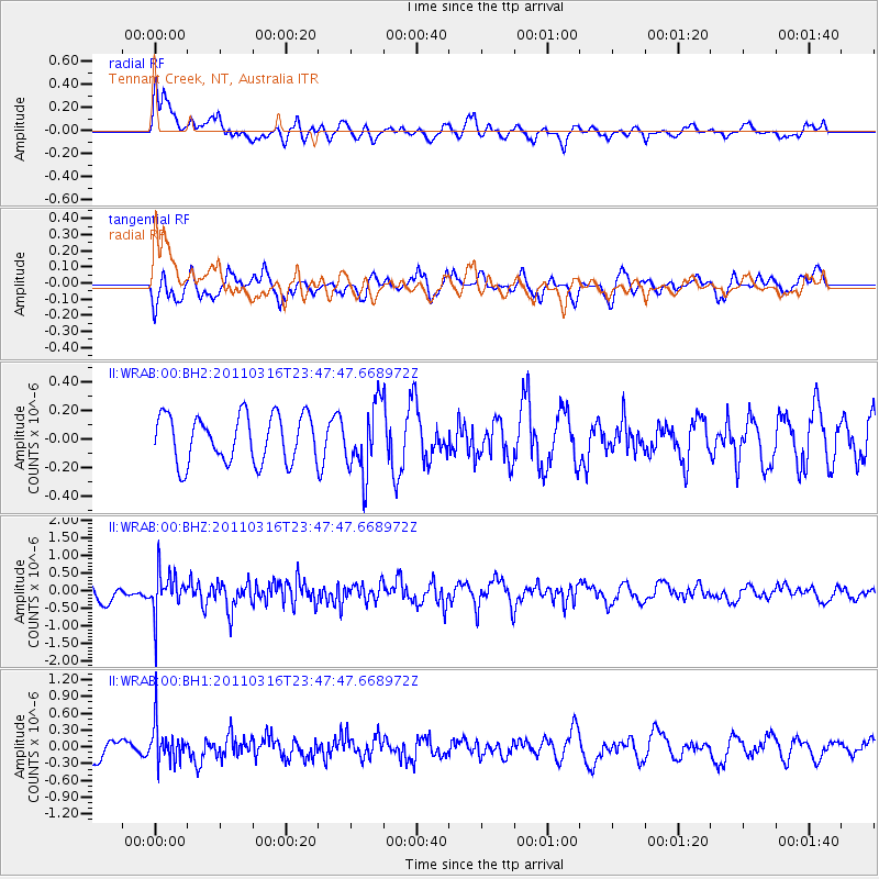
WRAB Tennant Creek, NT, Australia - Earthquake Result Viewer
*The percent match for this event was below the threshold and hence no stack was calculated.
| Earthquake location: |
Near East Coast Of Honshu, Japan |
| Earthquake latitude/longitude: |
39.1/142.5 |
| Earthquake time(UTC): |
2011/03/16 (075) 23:38:20 GMT |
| Earthquake Depth: |
35 km |
| Earthquake Magnitude: |
5.7 MB |
| Earthquake Catalog/Contributor: |
NEIC PDE/NEIC PDE-M |
|
| Network: |
II Global Seismograph Network (GSN - IRIS/IDA) |
| Station: |
WRAB Tennant Creek, NT, Australia |
| Lat/Lon: |
19.93 S/134.36 E |
| Elevation: |
366 m |
|
| Distance: |
59.3 deg |
| Az: |
188.953 deg |
| Baz: |
7.392 deg |
| Ray Param: |
$rayparam |
*The percent match for this event was below the threshold and hence was not used in the summary stack. |
|
| Radial Match: |
70.19973 % |
| Radial Bump: |
400 |
| Transverse Match: |
62.45293 % |
| Transverse Bump: |
400 |
| SOD ConfigId: |
558545 |
| Insert Time: |
2013-09-18 14:07:14.747 +0000 |
| GWidth: |
2.5 |
| Max Bumps: |
400 |
| Tol: |
0.001 |
|
Signal To Noise
| Channel | StoN | STA | LTA |
| II:WRAB:00:BHZ:20110316T23:47:47.668972Z | 2.4367101 | 6.0525235E-7 | 2.4838914E-7 |
| II:WRAB:00:BH1:20110316T23:47:47.668972Z | 1.9405481 | 3.4525766E-7 | 1.779176E-7 |
| II:WRAB:00:BH2:20110316T23:47:47.668972Z | 1.4574629 | 2.4089155E-7 | 1.6528143E-7 |
| Arrivals |
| Ps | |
| PpPs | |
| PsPs/PpSs | |


