You are here: Home > Network List > II - Global Seismograph Network (GSN - IRIS/IDA) Stations List
> Station KAPI Kappang, Sulawesi, Indonesia > Earthquake Result Viewer
KAPI Kappang, Sulawesi, Indonesia - Earthquake Result Viewer

| Earthquake location: |
Vanuatu Islands |
| Earthquake latitude/longitude: |
-17.3/167.8 |
| Earthquake time(UTC): |
2011/03/17 (076) 02:48:00 GMT |
| Earthquake Depth: |
17 km |
| Earthquake Magnitude: |
6.3 MW, 5.6 MB, 6.1 MS, 6.2 MW |
| Earthquake Catalog/Contributor: |
NEIC PDE/NEIC PDE-M |
|
| Network: |
II Global Seismograph Network (GSN - IRIS/IDA) |
| Station: |
KAPI Kappang, Sulawesi, Indonesia |
| Lat/Lon: |
5.01 S/119.75 E |
| Elevation: |
300 m |
|
| Distance: |
48.6 deg |
| Az: |
278.707 deg |
| Baz: |
108.554 deg |
| Ray Param: |
0.06925091 |
| Estimated Moho Depth: |
53.0 km |
| Estimated Crust Vp/Vs: |
1.62 |
| Assumed Crust Vp: |
6.343 km/s |
| Estimated Crust Vs: |
3.922 km/s |
| Estimated Crust Poisson's Ratio: |
0.19 |
|
| Radial Match: |
96.428696 % |
| Radial Bump: |
400 |
| Transverse Match: |
88.09134 % |
| Transverse Bump: |
400 |
| SOD ConfigId: |
558545 |
| Insert Time: |
2013-09-18 14:08:29.561 +0000 |
| GWidth: |
2.5 |
| Max Bumps: |
400 |
| Tol: |
0.001 |
|
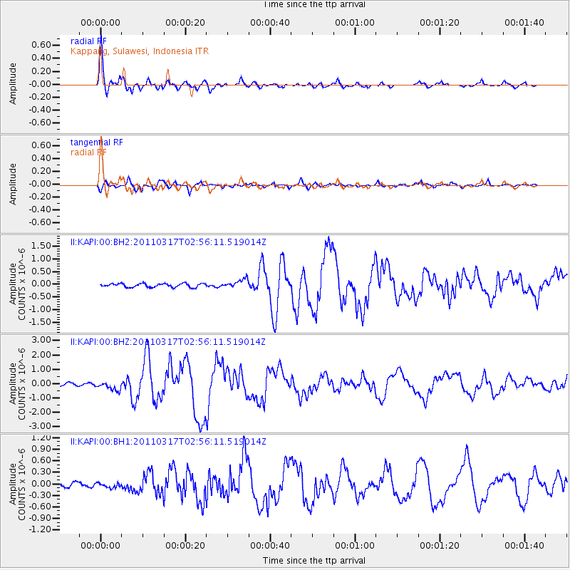
Signal To Noise
| Channel | StoN | STA | LTA |
| II:KAPI:00:BHZ:20110317T02:56:11.519014Z | 3.1098013 | 2.9153557E-7 | 9.3747325E-8 |
| II:KAPI:00:BH1:20110317T02:56:11.519014Z | 0.967792 | 6.026531E-8 | 6.2270935E-8 |
| II:KAPI:00:BH2:20110317T02:56:11.519014Z | 2.4703355 | 1.7827888E-7 | 7.2167886E-8 |
| Arrivals |
| Ps | 5.5 SECOND |
| PpPs | 21 SECOND |
| PsPs/PpSs | 26 SECOND |


