You are here: Home > Network List > IU - Global Seismograph Network (GSN - IRIS/USGS) Stations List
> Station MAKZ Makanchi, Kazakhstan > Earthquake Result Viewer
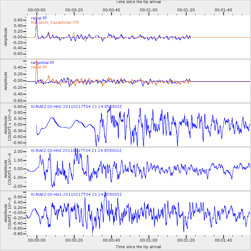
MAKZ Makanchi, Kazakhstan - Earthquake Result Viewer
*The percent match for this event was below the threshold and hence no stack was calculated.
| Earthquake location: |
Near East Coast Of Honshu, Japan |
| Earthquake latitude/longitude: |
40.1/142.2 |
| Earthquake time(UTC): |
2011/03/17 (076) 04:13:56 GMT |
| Earthquake Depth: |
29 km |
| Earthquake Magnitude: |
6.1 MW, 5.8 MB, 5.8 MS, 6.2 MW |
| Earthquake Catalog/Contributor: |
NEIC PDE/NEIC PDE-M |
|
| Network: |
IU Global Seismograph Network (GSN - IRIS/USGS) |
| Station: |
MAKZ Makanchi, Kazakhstan |
| Lat/Lon: |
46.81 N/81.98 E |
| Elevation: |
600 m |
|
| Distance: |
43.2 deg |
| Az: |
299.553 deg |
| Baz: |
76.146 deg |
| Ray Param: |
$rayparam |
*The percent match for this event was below the threshold and hence was not used in the summary stack. |
|
| Radial Match: |
77.32251 % |
| Radial Bump: |
397 |
| Transverse Match: |
58.089497 % |
| Transverse Bump: |
400 |
| SOD ConfigId: |
558545 |
| Insert Time: |
2013-09-18 14:09:51.411 +0000 |
| GWidth: |
2.5 |
| Max Bumps: |
400 |
| Tol: |
0.001 |
|
Signal To Noise
| Channel | StoN | STA | LTA |
| IU:MAKZ:00:HHZ:20110317T04:21:24.858003Z | 3.704406 | 7.4018254E-7 | 1.998114E-7 |
| IU:MAKZ:00:HH1:20110317T04:21:24.858003Z | 1.3673861 | 1.811959E-7 | 1.3251261E-7 |
| IU:MAKZ:00:HH2:20110317T04:21:24.858003Z | 2.3416004 | 4.795336E-7 | 2.0478882E-7 |
| Arrivals |
| Ps | |
| PpPs | |
| PsPs/PpSs | |


