You are here: Home > Network List > II - Global Seismograph Network (GSN - IRIS/IDA) Stations List
> Station KAPI Kappang, Sulawesi, Indonesia > Earthquake Result Viewer
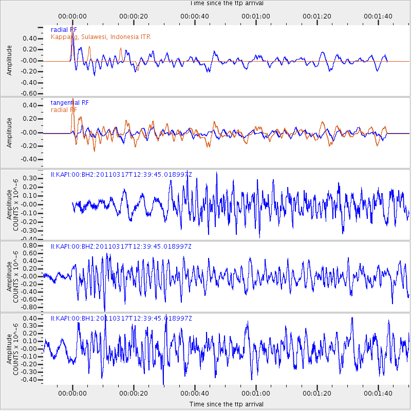
KAPI Kappang, Sulawesi, Indonesia - Earthquake Result Viewer
*The percent match for this event was below the threshold and hence no stack was calculated.
| Earthquake location: |
Near East Coast Of Honshu, Japan |
| Earthquake latitude/longitude: |
35.5/140.8 |
| Earthquake time(UTC): |
2011/03/17 (076) 12:32:04 GMT |
| Earthquake Depth: |
36 km |
| Earthquake Magnitude: |
5.5 MW, 5.5 MW |
| Earthquake Catalog/Contributor: |
NEIC PDE/NEIC PDE-M |
|
| Network: |
II Global Seismograph Network (GSN - IRIS/IDA) |
| Station: |
KAPI Kappang, Sulawesi, Indonesia |
| Lat/Lon: |
5.01 S/119.75 E |
| Elevation: |
300 m |
|
| Distance: |
44.9 deg |
| Az: |
210.416 deg |
| Baz: |
24.5 deg |
| Ray Param: |
$rayparam |
*The percent match for this event was below the threshold and hence was not used in the summary stack. |
|
| Radial Match: |
75.095604 % |
| Radial Bump: |
400 |
| Transverse Match: |
50.949875 % |
| Transverse Bump: |
400 |
| SOD ConfigId: |
558545 |
| Insert Time: |
2013-09-18 14:12:01.516 +0000 |
| GWidth: |
2.5 |
| Max Bumps: |
400 |
| Tol: |
0.001 |
|
Signal To Noise
| Channel | StoN | STA | LTA |
| II:KAPI:00:BHZ:20110317T12:39:45.018997Z | 3.1216295 | 2.603387E-7 | 8.3398334E-8 |
| II:KAPI:00:BH1:20110317T12:39:45.018997Z | 1.985929 | 1.5117625E-7 | 7.61237E-8 |
| II:KAPI:00:BH2:20110317T12:39:45.018997Z | 1.7974626 | 1.2639448E-7 | 7.031828E-8 |
| Arrivals |
| Ps | |
| PpPs | |
| PsPs/PpSs | |


