You are here: Home > Network List > IU - Global Seismograph Network (GSN - IRIS/USGS) Stations List
> Station PMG Port Moresby, New Guinea > Earthquake Result Viewer
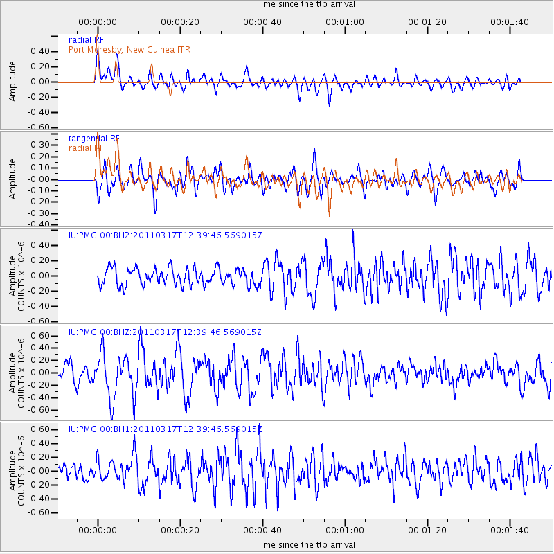
PMG Port Moresby, New Guinea - Earthquake Result Viewer
*The percent match for this event was below the threshold and hence no stack was calculated.
| Earthquake location: |
Near East Coast Of Honshu, Japan |
| Earthquake latitude/longitude: |
35.5/140.8 |
| Earthquake time(UTC): |
2011/03/17 (076) 12:32:04 GMT |
| Earthquake Depth: |
36 km |
| Earthquake Magnitude: |
5.5 MW, 5.5 MW |
| Earthquake Catalog/Contributor: |
NEIC PDE/NEIC PDE-M |
|
| Network: |
IU Global Seismograph Network (GSN - IRIS/USGS) |
| Station: |
PMG Port Moresby, New Guinea |
| Lat/Lon: |
9.40 S/147.16 E |
| Elevation: |
90 m |
|
| Distance: |
45.1 deg |
| Az: |
171.066 deg |
| Baz: |
352.621 deg |
| Ray Param: |
$rayparam |
*The percent match for this event was below the threshold and hence was not used in the summary stack. |
|
| Radial Match: |
68.702484 % |
| Radial Bump: |
400 |
| Transverse Match: |
65.14971 % |
| Transverse Bump: |
400 |
| SOD ConfigId: |
558545 |
| Insert Time: |
2013-09-18 14:12:30.544 +0000 |
| GWidth: |
2.5 |
| Max Bumps: |
400 |
| Tol: |
0.001 |
|
Signal To Noise
| Channel | StoN | STA | LTA |
| IU:PMG:00:BHZ:20110317T12:39:46.569015Z | 3.3024101 | 3.8307903E-7 | 1.1599983E-7 |
| IU:PMG:00:BH1:20110317T12:39:46.569015Z | 1.150519 | 1.2743303E-7 | 1.10761334E-7 |
| IU:PMG:00:BH2:20110317T12:39:46.569015Z | 0.8420051 | 9.136334E-8 | 1.08506875E-7 |
| Arrivals |
| Ps | |
| PpPs | |
| PsPs/PpSs | |


