You are here: Home > Network List > II - Global Seismograph Network (GSN - IRIS/IDA) Stations List
> Station PFO Pinon Flat, California, USA > Earthquake Result Viewer
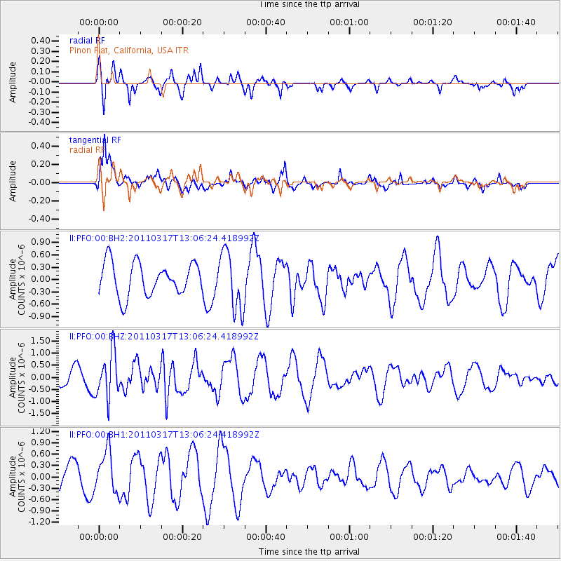
PFO Pinon Flat, California, USA - Earthquake Result Viewer
*The percent match for this event was below the threshold and hence no stack was calculated.
| Earthquake location: |
Near East Coast Of Honshu, Japan |
| Earthquake latitude/longitude: |
36.8/141.2 |
| Earthquake time(UTC): |
2011/03/17 (076) 12:54:52 GMT |
| Earthquake Depth: |
29 km |
| Earthquake Magnitude: |
5.8 MW, 5.9 MW, 6.1 MB |
| Earthquake Catalog/Contributor: |
NEIC PDE/NEIC PDE-M |
|
| Network: |
II Global Seismograph Network (GSN - IRIS/IDA) |
| Station: |
PFO Pinon Flat, California, USA |
| Lat/Lon: |
33.61 N/116.46 W |
| Elevation: |
1280 m |
|
| Distance: |
79.3 deg |
| Az: |
56.054 deg |
| Baz: |
307.03 deg |
| Ray Param: |
$rayparam |
*The percent match for this event was below the threshold and hence was not used in the summary stack. |
|
| Radial Match: |
62.810287 % |
| Radial Bump: |
284 |
| Transverse Match: |
64.60445 % |
| Transverse Bump: |
361 |
| SOD ConfigId: |
558545 |
| Insert Time: |
2013-09-18 14:13:08.892 +0000 |
| GWidth: |
2.5 |
| Max Bumps: |
400 |
| Tol: |
0.001 |
|
Signal To Noise
| Channel | StoN | STA | LTA |
| II:PFO:00:BHZ:20110317T13:06:24.418992Z | 2.8389397 | 9.4628774E-7 | 3.3332435E-7 |
| II:PFO:00:BH1:20110317T13:06:24.418992Z | 1.4509628 | 5.578278E-7 | 3.8445353E-7 |
| II:PFO:00:BH2:20110317T13:06:24.418992Z | 1.8580704 | 7.3575563E-7 | 3.9597836E-7 |
| Arrivals |
| Ps | |
| PpPs | |
| PsPs/PpSs | |


