You are here: Home > Network List > IU - Global Seismograph Network (GSN - IRIS/USGS) Stations List
> Station RSSD Black Hills, South Dakota, USA > Earthquake Result Viewer
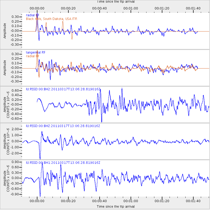
RSSD Black Hills, South Dakota, USA - Earthquake Result Viewer
*The percent match for this event was below the threshold and hence no stack was calculated.
| Earthquake location: |
Near East Coast Of Honshu, Japan |
| Earthquake latitude/longitude: |
36.8/141.2 |
| Earthquake time(UTC): |
2011/03/17 (076) 12:54:52 GMT |
| Earthquake Depth: |
29 km |
| Earthquake Magnitude: |
5.8 MW, 5.9 MW, 6.1 MB |
| Earthquake Catalog/Contributor: |
NEIC PDE/NEIC PDE-M |
|
| Network: |
IU Global Seismograph Network (GSN - IRIS/USGS) |
| Station: |
RSSD Black Hills, South Dakota, USA |
| Lat/Lon: |
44.12 N/104.04 W |
| Elevation: |
2090 m |
|
| Distance: |
80.1 deg |
| Az: |
41.588 deg |
| Baz: |
312.254 deg |
| Ray Param: |
$rayparam |
*The percent match for this event was below the threshold and hence was not used in the summary stack. |
|
| Radial Match: |
68.56926 % |
| Radial Bump: |
355 |
| Transverse Match: |
71.02523 % |
| Transverse Bump: |
400 |
| SOD ConfigId: |
558545 |
| Insert Time: |
2013-09-18 14:13:49.363 +0000 |
| GWidth: |
2.5 |
| Max Bumps: |
400 |
| Tol: |
0.001 |
|
Signal To Noise
| Channel | StoN | STA | LTA |
| IU:RSSD:00:BHZ:20110317T13:06:28.819016Z | 6.00718 | 1.0504074E-6 | 1.7485866E-7 |
| IU:RSSD:00:BH1:20110317T13:06:28.819016Z | 2.253978 | 4.2812266E-7 | 1.8994092E-7 |
| IU:RSSD:00:BH2:20110317T13:06:28.819016Z | 1.2199687 | 1.4818512E-7 | 1.2146634E-7 |
| Arrivals |
| Ps | |
| PpPs | |
| PsPs/PpSs | |


