KAPI Kappang, Sulawesi, Indonesia - Earthquake Result Viewer
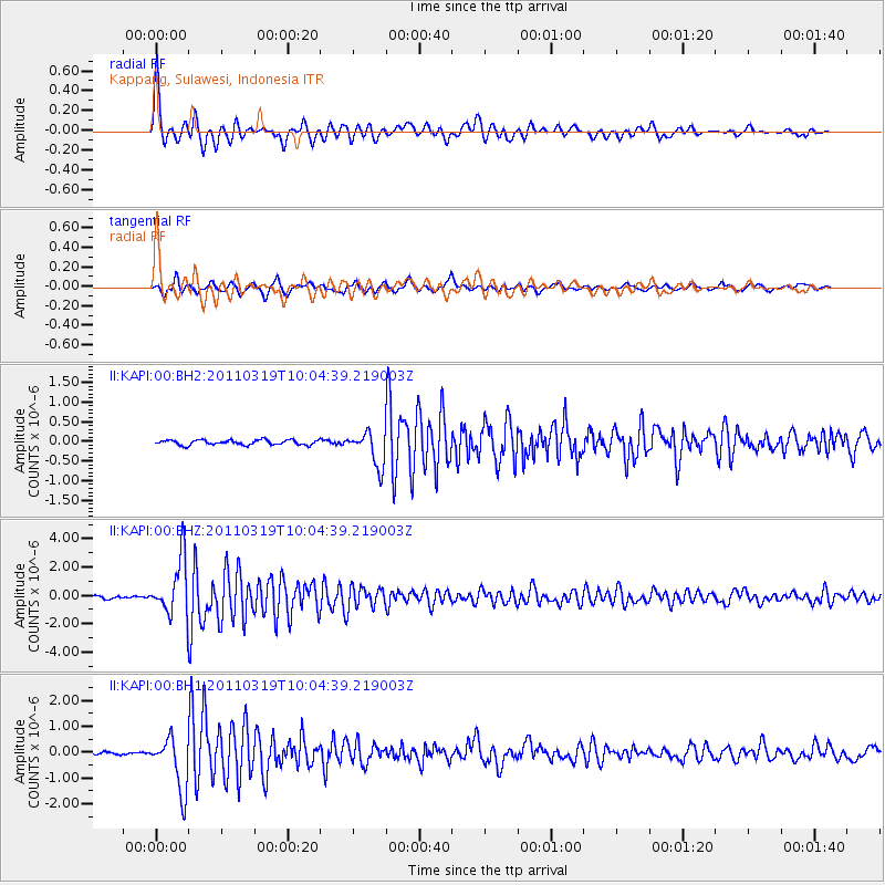
Earthquake location: Near East Coast Of Honshu, Japan
Earthquake latitude/longitude: 36.8/140.3
Earthquake time(UTC): 2011/03/19 (078) 09:56:47 GMT
Earthquake Depth: 6.0 km
Earthquake Magnitude: 5.7 MW, 5.5 MS, 5.7 MW, 6.1 MB
Earthquake Catalog/Contributor: NEIC PDE/NEIC PDE-M
Network: II Global Seismograph Network (GSN - IRIS/IDA)
Station: KAPI Kappang, Sulawesi, Indonesia
Lat/Lon: 5.01 S/119.75 E
Elevation: 300 m
Distance: 45.8 deg
Az: 209.145 deg
Baz: 23.105 deg
Ray Param: 0.071049966
Estimated Moho Depth: 35.75 km
Estimated Crust Vp/Vs: 1.79
Assumed Crust Vp: 6.343 km/s
Estimated Crust Vs: 3.554 km/s
Estimated Crust Poisson's Ratio: 0.27
Radial Match: 92.825775 %
Radial Bump: 400
Transverse Match: 89.42626 %
Transverse Bump: 400
SOD ConfigId: 558545
Insert Time: 2013-09-18 14:20:07.277 +0000
GWidth: 2.5
Max Bumps: 400
Tol: 0.001

Signal To Noise

ChannelStoNSTALTA
II:KAPI:00:BHZ:20110319T10:04:39.219003Z27.8428631.965147E-67.057992E-8
II:KAPI:00:BH1:20110319T10:04:39.219003Z19.9917721.0288181E-65.1462077E-8
II:KAPI:00:BH2:20110319T10:04:39.219003Z7.17080164.3818653E-76.1107045E-8
Arrivals
Ps4.7 SECOND
PpPs15 SECOND
PsPs/PpSs19 SECOND