You are here: Home > Network List > CN - Canadian National Seismograph Network Stations List
> Station FRB IQALUIT, N.W.T. > Earthquake Result Viewer
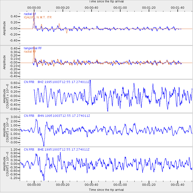
FRB IQALUIT, N.W.T. - Earthquake Result Viewer
*The percent match for this event was below the threshold and hence no stack was calculated.
| Earthquake location: |
Peru-Ecuador Border Region |
| Earthquake latitude/longitude: |
-2.8/-77.9 |
| Earthquake time(UTC): |
1995/10/03 (276) 12:45:00 GMT |
| Earthquake Depth: |
33 km |
| Earthquake Magnitude: |
6.0 MB, 6.1 MS, 5.9 UNKNOWN, 6.4 MW |
| Earthquake Catalog/Contributor: |
WHDF/NEIC |
|
| Network: |
CN Canadian National Seismograph Network |
| Station: |
FRB IQALUIT, N.W.T. |
| Lat/Lon: |
63.75 N/68.55 W |
| Elevation: |
18 m |
|
| Distance: |
66.8 deg |
| Az: |
4.51 deg |
| Baz: |
190.172 deg |
| Ray Param: |
$rayparam |
*The percent match for this event was below the threshold and hence was not used in the summary stack. |
|
| Radial Match: |
77.64483 % |
| Radial Bump: |
400 |
| Transverse Match: |
57.708347 % |
| Transverse Bump: |
400 |
| SOD ConfigId: |
4480 |
| Insert Time: |
2010-02-27 05:54:39.906 +0000 |
| GWidth: |
2.5 |
| Max Bumps: |
400 |
| Tol: |
0.001 |
|
Signal To Noise
| Channel | StoN | STA | LTA |
| CN:FRB: :BHN:19951003T12:55:17.274011Z | 4.140662 | 1.2184588E-6 | 2.9426667E-7 |
| CN:FRB: :BHE:19951003T12:55:17.274011Z | 3.5159833 | 4.715922E-7 | 1.341281E-7 |
| CN:FRB: :BHZ:19951003T12:55:17.274011Z | 0.5346443 | 1.2356044E-7 | 2.3110776E-7 |
| Arrivals |
| Ps | |
| PpPs | |
| PsPs/PpSs | |


