You are here: Home > Network List > II - Global Seismograph Network (GSN - IRIS/IDA) Stations List
> Station WRAB Tennant Creek, NT, Australia > Earthquake Result Viewer
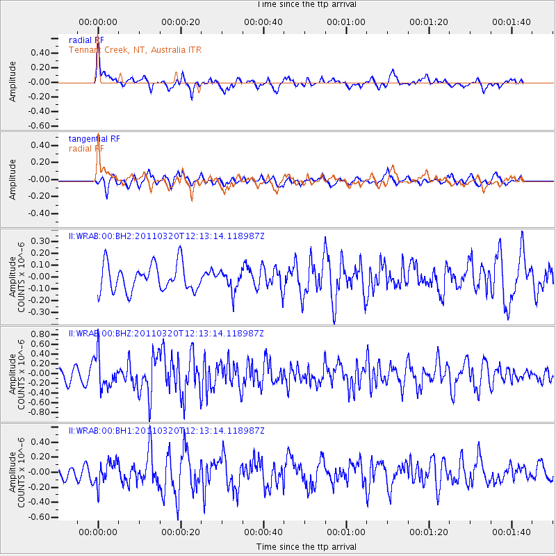
WRAB Tennant Creek, NT, Australia - Earthquake Result Viewer
*The percent match for this event was below the threshold and hence no stack was calculated.
| Earthquake location: |
Eastern Honshu, Japan |
| Earthquake latitude/longitude: |
39.3/141.8 |
| Earthquake time(UTC): |
2011/03/20 (079) 12:03:46 GMT |
| Earthquake Depth: |
42 km |
| Earthquake Magnitude: |
5.8 MW, 5.8 MW, 5.9 MB |
| Earthquake Catalog/Contributor: |
NEIC PDE/NEIC PDE-M |
|
| Network: |
II Global Seismograph Network (GSN - IRIS/IDA) |
| Station: |
WRAB Tennant Creek, NT, Australia |
| Lat/Lon: |
19.93 S/134.36 E |
| Elevation: |
366 m |
|
| Distance: |
59.4 deg |
| Az: |
188.164 deg |
| Baz: |
6.721 deg |
| Ray Param: |
$rayparam |
*The percent match for this event was below the threshold and hence was not used in the summary stack. |
|
| Radial Match: |
69.104965 % |
| Radial Bump: |
391 |
| Transverse Match: |
64.34935 % |
| Transverse Bump: |
354 |
| SOD ConfigId: |
558545 |
| Insert Time: |
2013-09-18 14:25:25.671 +0000 |
| GWidth: |
2.5 |
| Max Bumps: |
400 |
| Tol: |
0.001 |
|
Signal To Noise
| Channel | StoN | STA | LTA |
| II:WRAB:00:BHZ:20110320T12:13:14.118987Z | 3.3264003 | 3.3011742E-7 | 9.9241646E-8 |
| II:WRAB:00:BH1:20110320T12:13:14.118987Z | 1.2243685 | 1.5331102E-7 | 1.252164E-7 |
| II:WRAB:00:BH2:20110320T12:13:14.118987Z | 0.7809929 | 8.8234565E-8 | 1.1297742E-7 |
| Arrivals |
| Ps | |
| PpPs | |
| PsPs/PpSs | |


