You are here: Home > Network List > IU - Global Seismograph Network (GSN - IRIS/USGS) Stations List
> Station HNR Honiara, Solomon Islands > Earthquake Result Viewer
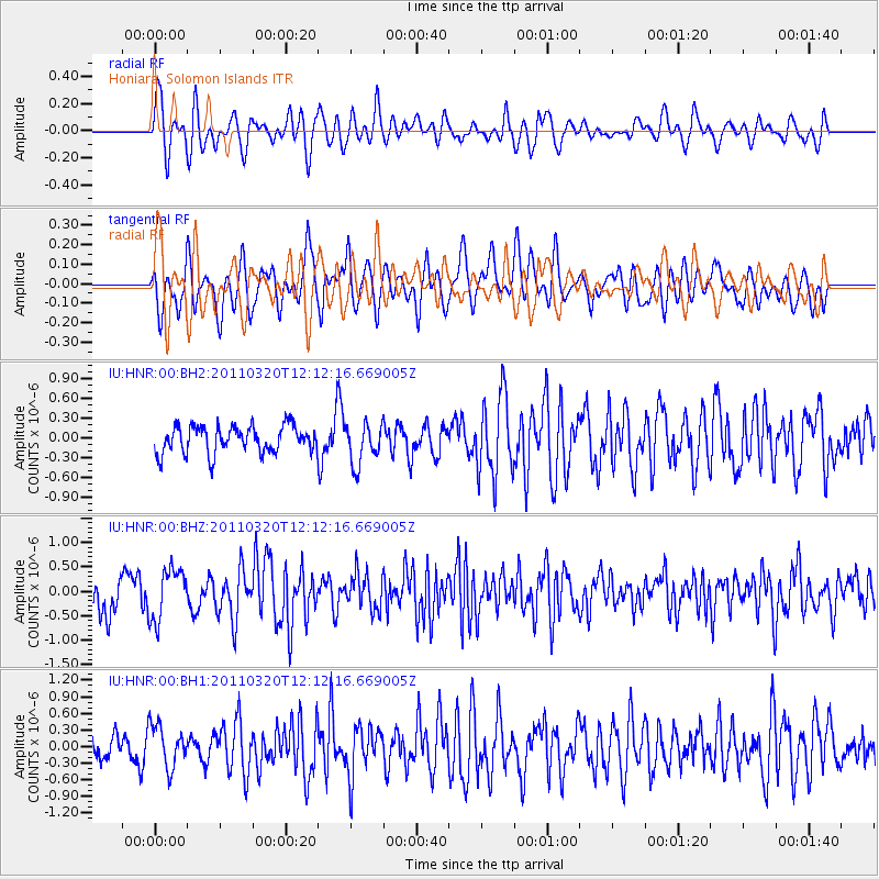
HNR Honiara, Solomon Islands - Earthquake Result Viewer
*The percent match for this event was below the threshold and hence no stack was calculated.
| Earthquake location: |
Eastern Honshu, Japan |
| Earthquake latitude/longitude: |
39.3/141.8 |
| Earthquake time(UTC): |
2011/03/20 (079) 12:03:46 GMT |
| Earthquake Depth: |
42 km |
| Earthquake Magnitude: |
5.8 MW, 5.8 MW, 5.9 MB |
| Earthquake Catalog/Contributor: |
NEIC PDE/NEIC PDE-M |
|
| Network: |
IU Global Seismograph Network (GSN - IRIS/USGS) |
| Station: |
HNR Honiara, Solomon Islands |
| Lat/Lon: |
9.44 S/159.95 E |
| Elevation: |
100 m |
|
| Distance: |
51.4 deg |
| Az: |
156.87 deg |
| Baz: |
342.019 deg |
| Ray Param: |
$rayparam |
*The percent match for this event was below the threshold and hence was not used in the summary stack. |
|
| Radial Match: |
73.50065 % |
| Radial Bump: |
400 |
| Transverse Match: |
70.261116 % |
| Transverse Bump: |
400 |
| SOD ConfigId: |
558545 |
| Insert Time: |
2013-09-18 14:25:43.558 +0000 |
| GWidth: |
2.5 |
| Max Bumps: |
400 |
| Tol: |
0.001 |
|
Signal To Noise
| Channel | StoN | STA | LTA |
| IU:HNR:00:BHZ:20110320T12:12:16.669005Z | 2.1124015 | 5.2024365E-7 | 2.4628068E-7 |
| IU:HNR:00:BH1:20110320T12:12:16.669005Z | 2.1690633 | 3.8078107E-7 | 1.7555092E-7 |
| IU:HNR:00:BH2:20110320T12:12:16.669005Z | 1.5158148 | 3.0842753E-7 | 2.034731E-7 |
| Arrivals |
| Ps | |
| PpPs | |
| PsPs/PpSs | |


