You are here: Home > Network List > IU - Global Seismograph Network (GSN - IRIS/USGS) Stations List
> Station RSSD Black Hills, South Dakota, USA > Earthquake Result Viewer
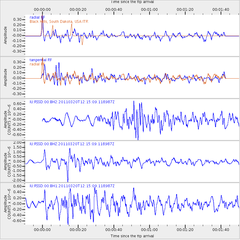
RSSD Black Hills, South Dakota, USA - Earthquake Result Viewer
*The percent match for this event was below the threshold and hence no stack was calculated.
| Earthquake location: |
Eastern Honshu, Japan |
| Earthquake latitude/longitude: |
39.3/141.8 |
| Earthquake time(UTC): |
2011/03/20 (079) 12:03:46 GMT |
| Earthquake Depth: |
42 km |
| Earthquake Magnitude: |
5.8 MW, 5.8 MW, 5.9 MB |
| Earthquake Catalog/Contributor: |
NEIC PDE/NEIC PDE-M |
|
| Network: |
IU Global Seismograph Network (GSN - IRIS/USGS) |
| Station: |
RSSD Black Hills, South Dakota, USA |
| Lat/Lon: |
44.12 N/104.04 W |
| Elevation: |
2090 m |
|
| Distance: |
77.9 deg |
| Az: |
42.235 deg |
| Baz: |
313.643 deg |
| Ray Param: |
$rayparam |
*The percent match for this event was below the threshold and hence was not used in the summary stack. |
|
| Radial Match: |
61.631233 % |
| Radial Bump: |
394 |
| Transverse Match: |
71.94823 % |
| Transverse Bump: |
400 |
| SOD ConfigId: |
558545 |
| Insert Time: |
2013-09-18 14:25:59.810 +0000 |
| GWidth: |
2.5 |
| Max Bumps: |
400 |
| Tol: |
0.001 |
|
Signal To Noise
| Channel | StoN | STA | LTA |
| IU:RSSD:00:BHZ:20110320T12:15:09.118987Z | 3.926351 | 5.566557E-7 | 1.4177431E-7 |
| IU:RSSD:00:BH1:20110320T12:15:09.118987Z | 1.6795627 | 2.2699211E-7 | 1.3514953E-7 |
| IU:RSSD:00:BH2:20110320T12:15:09.118987Z | 0.8227335 | 8.935309E-8 | 1.08605136E-7 |
| Arrivals |
| Ps | |
| PpPs | |
| PsPs/PpSs | |


