You are here: Home > Network List > II - Global Seismograph Network (GSN - IRIS/IDA) Stations List
> Station WRAB Tennant Creek, NT, Australia > Earthquake Result Viewer
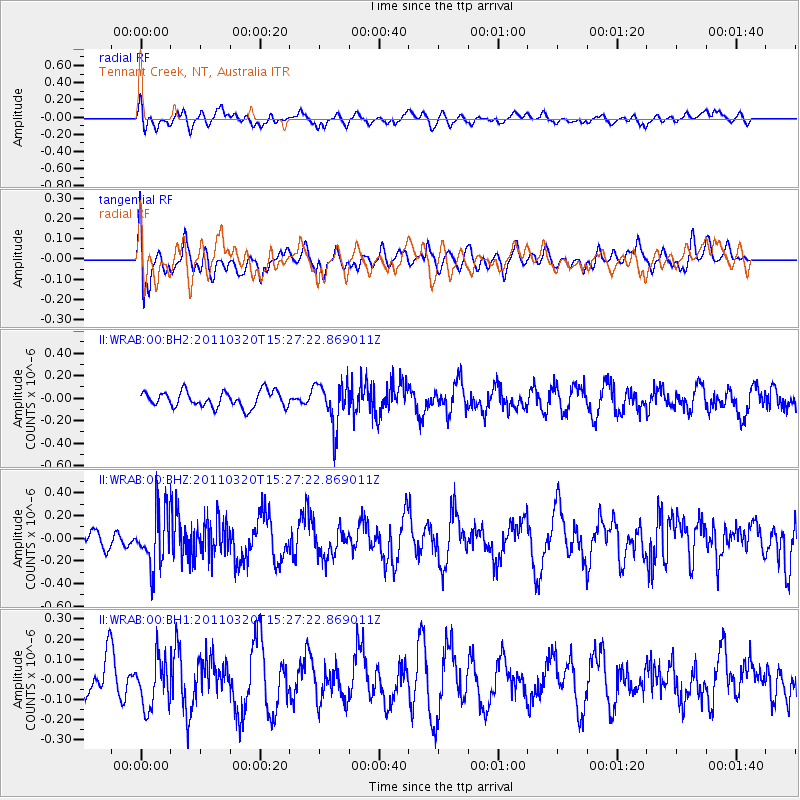
WRAB Tennant Creek, NT, Australia - Earthquake Result Viewer
*The percent match for this event was below the threshold and hence no stack was calculated.
| Earthquake location: |
Kermadec Islands Region |
| Earthquake latitude/longitude: |
-31.1/-179.8 |
| Earthquake time(UTC): |
2011/03/20 (079) 15:20:28 GMT |
| Earthquake Depth: |
321 km |
| Earthquake Magnitude: |
5.7 MW |
| Earthquake Catalog/Contributor: |
NEIC PDE/NEIC PDE-M |
|
| Network: |
II Global Seismograph Network (GSN - IRIS/IDA) |
| Station: |
WRAB Tennant Creek, NT, Australia |
| Lat/Lon: |
19.93 S/134.36 E |
| Elevation: |
366 m |
|
| Distance: |
42.6 deg |
| Az: |
273.958 deg |
| Baz: |
114.591 deg |
| Ray Param: |
$rayparam |
*The percent match for this event was below the threshold and hence was not used in the summary stack. |
|
| Radial Match: |
52.24118 % |
| Radial Bump: |
400 |
| Transverse Match: |
49.774837 % |
| Transverse Bump: |
400 |
| SOD ConfigId: |
558545 |
| Insert Time: |
2013-09-18 14:26:35.133 +0000 |
| GWidth: |
2.5 |
| Max Bumps: |
400 |
| Tol: |
0.001 |
|
Signal To Noise
| Channel | StoN | STA | LTA |
| II:WRAB:00:BHZ:20110320T15:27:22.869011Z | 2.9552922 | 2.4676248E-7 | 8.3498506E-8 |
| II:WRAB:00:BH1:20110320T15:27:22.869011Z | 1.4520192 | 1.1949564E-7 | 8.229618E-8 |
| II:WRAB:00:BH2:20110320T15:27:22.869011Z | 2.818406 | 1.988613E-7 | 7.0558066E-8 |
| Arrivals |
| Ps | |
| PpPs | |
| PsPs/PpSs | |


