You are here: Home > Network List > IU - Global Seismograph Network (GSN - IRIS/USGS) Stations List
> Station PMG Port Moresby, New Guinea > Earthquake Result Viewer
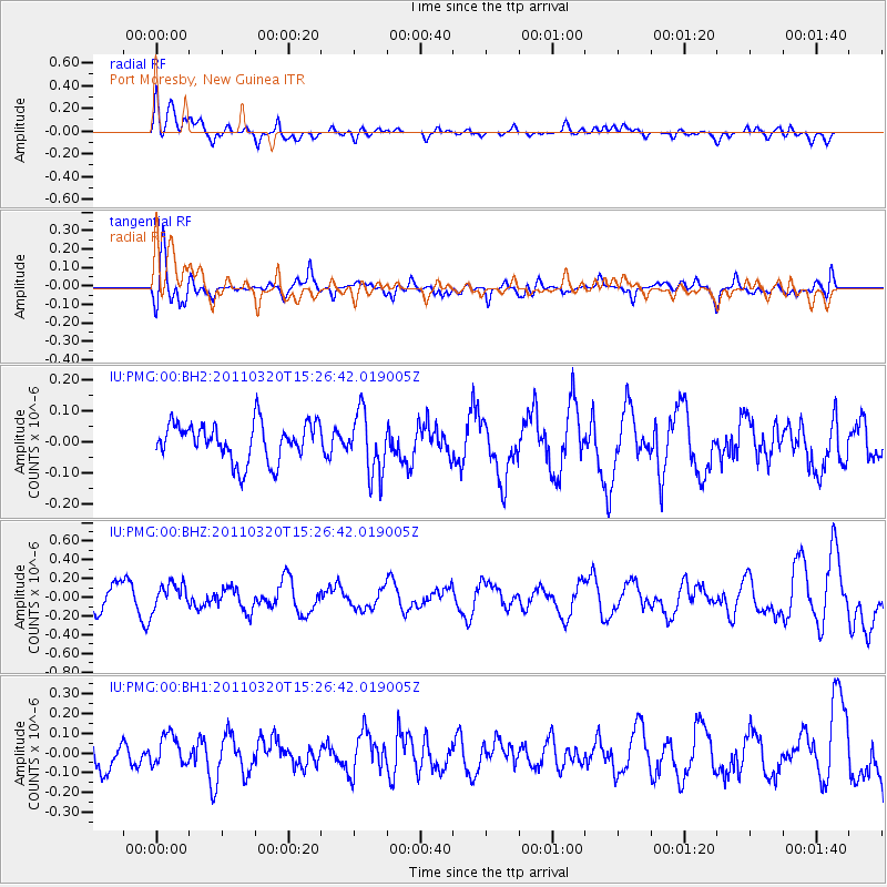
PMG Port Moresby, New Guinea - Earthquake Result Viewer
*The percent match for this event was below the threshold and hence no stack was calculated.
| Earthquake location: |
Kermadec Islands Region |
| Earthquake latitude/longitude: |
-31.1/-179.8 |
| Earthquake time(UTC): |
2011/03/20 (079) 15:20:28 GMT |
| Earthquake Depth: |
321 km |
| Earthquake Magnitude: |
5.7 MW |
| Earthquake Catalog/Contributor: |
NEIC PDE/NEIC PDE-M |
|
| Network: |
IU Global Seismograph Network (GSN - IRIS/USGS) |
| Station: |
PMG Port Moresby, New Guinea |
| Lat/Lon: |
9.40 S/147.16 E |
| Elevation: |
90 m |
|
| Distance: |
37.5 deg |
| Az: |
298.044 deg |
| Baz: |
129.913 deg |
| Ray Param: |
$rayparam |
*The percent match for this event was below the threshold and hence was not used in the summary stack. |
|
| Radial Match: |
62.0619 % |
| Radial Bump: |
400 |
| Transverse Match: |
60.44814 % |
| Transverse Bump: |
400 |
| SOD ConfigId: |
558545 |
| Insert Time: |
2013-09-18 14:26:45.873 +0000 |
| GWidth: |
2.5 |
| Max Bumps: |
400 |
| Tol: |
0.001 |
|
Signal To Noise
| Channel | StoN | STA | LTA |
| IU:PMG:00:BHZ:20110320T15:26:42.019005Z | 1.5428605 | 1.343313E-7 | 8.70664E-8 |
| IU:PMG:00:BH1:20110320T15:26:42.019005Z | 0.94770056 | 8.4542656E-8 | 8.920819E-8 |
| IU:PMG:00:BH2:20110320T15:26:42.019005Z | 1.610826 | 9.842568E-8 | 6.110261E-8 |
| Arrivals |
| Ps | |
| PpPs | |
| PsPs/PpSs | |


