You are here: Home > Network List > II - Global Seismograph Network (GSN - IRIS/IDA) Stations List
> Station WRAB Tennant Creek, NT, Australia > Earthquake Result Viewer
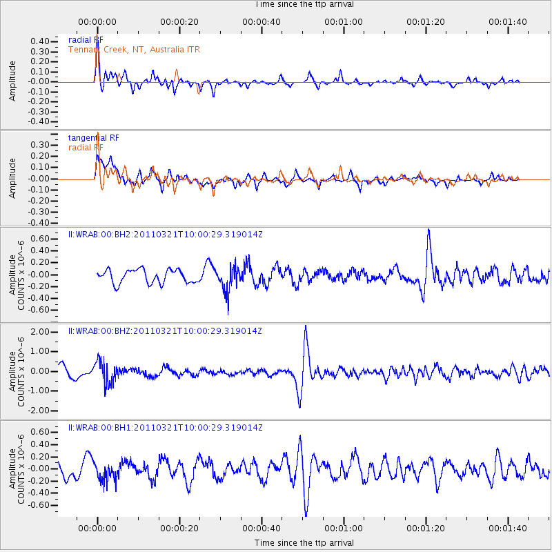
WRAB Tennant Creek, NT, Australia - Earthquake Result Viewer
*The percent match for this event was below the threshold and hence no stack was calculated.
| Earthquake location: |
Hindu Kush Region, Afghanistan |
| Earthquake latitude/longitude: |
36.5/70.9 |
| Earthquake time(UTC): |
2011/03/21 (080) 09:49:01 GMT |
| Earthquake Depth: |
190 km |
| Earthquake Magnitude: |
5.8 MW, 5.5 MB, 5.8 MW |
| Earthquake Catalog/Contributor: |
NEIC PDE/NEIC PDE-M |
|
| Network: |
II Global Seismograph Network (GSN - IRIS/IDA) |
| Station: |
WRAB Tennant Creek, NT, Australia |
| Lat/Lon: |
19.93 S/134.36 E |
| Elevation: |
366 m |
|
| Distance: |
82.0 deg |
| Az: |
121.826 deg |
| Baz: |
313.3 deg |
| Ray Param: |
$rayparam |
*The percent match for this event was below the threshold and hence was not used in the summary stack. |
|
| Radial Match: |
75.30699 % |
| Radial Bump: |
400 |
| Transverse Match: |
61.067883 % |
| Transverse Bump: |
400 |
| SOD ConfigId: |
558545 |
| Insert Time: |
2013-09-18 14:27:21.831 +0000 |
| GWidth: |
2.5 |
| Max Bumps: |
400 |
| Tol: |
0.001 |
|
Signal To Noise
| Channel | StoN | STA | LTA |
| II:WRAB:00:BHZ:20110321T10:00:29.319014Z | 2.467038 | 5.7879333E-7 | 2.3461064E-7 |
| II:WRAB:00:BH1:20110321T10:00:29.319014Z | 0.8700316 | 1.4556431E-7 | 1.6730924E-7 |
| II:WRAB:00:BH2:20110321T10:00:29.319014Z | 1.7710608 | 1.9933454E-7 | 1.1255092E-7 |
| Arrivals |
| Ps | |
| PpPs | |
| PsPs/PpSs | |


