You are here: Home > Network List > CN - Canadian National Seismograph Network Stations List
> Station FRB IQALUIT, N.W.T. > Earthquake Result Viewer
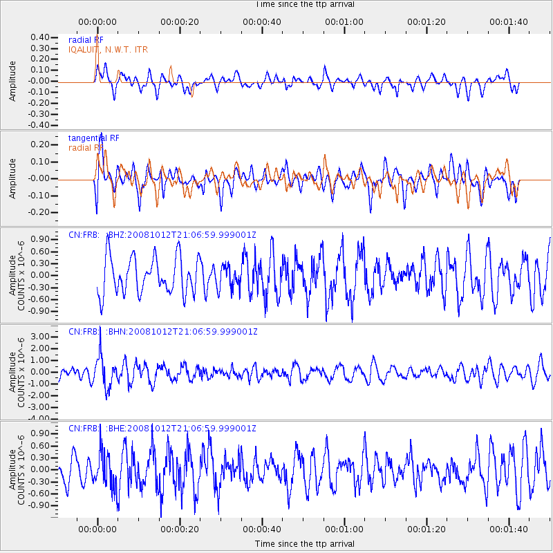
FRB IQALUIT, N.W.T. - Earthquake Result Viewer
*The percent match for this event was below the threshold and hence no stack was calculated.
| Earthquake location: |
Southern Bolivia |
| Earthquake latitude/longitude: |
-20.1/-65.0 |
| Earthquake time(UTC): |
2008/10/12 (286) 20:55:41 GMT |
| Earthquake Depth: |
353 km |
| Earthquake Magnitude: |
6.0 MB, 6.2 MW, 6.2 MW |
| Earthquake Catalog/Contributor: |
WHDF/NEIC |
|
| Network: |
CN Canadian National Seismograph Network |
| Station: |
FRB IQALUIT, N.W.T. |
| Lat/Lon: |
63.75 N/68.55 W |
| Elevation: |
18 m |
|
| Distance: |
83.6 deg |
| Az: |
358.401 deg |
| Baz: |
176.619 deg |
| Ray Param: |
$rayparam |
*The percent match for this event was below the threshold and hence was not used in the summary stack. |
|
| Radial Match: |
58.63472 % |
| Radial Bump: |
400 |
| Transverse Match: |
55.295845 % |
| Transverse Bump: |
400 |
| SOD ConfigId: |
2556 |
| Insert Time: |
2010-02-27 05:54:44.419 +0000 |
| GWidth: |
2.5 |
| Max Bumps: |
400 |
| Tol: |
0.001 |
|
Signal To Noise
| Channel | StoN | STA | LTA |
| CN:FRB: :BHN:20081012T21:06:59.999001Z | 2.3410625 | 1.319219E-6 | 5.635129E-7 |
| CN:FRB: :BHE:20081012T21:06:59.999001Z | 1.1850561 | 4.5563473E-7 | 3.8448368E-7 |
| CN:FRB: :BHZ:20081012T21:06:59.999001Z | 0.626165 | 2.8489066E-7 | 4.54977E-7 |
| Arrivals |
| Ps | |
| PpPs | |
| PsPs/PpSs | |


