You are here: Home > Network List > II - Global Seismograph Network (GSN - IRIS/IDA) Stations List
> Station WRAB Tennant Creek, NT, Australia > Earthquake Result Viewer
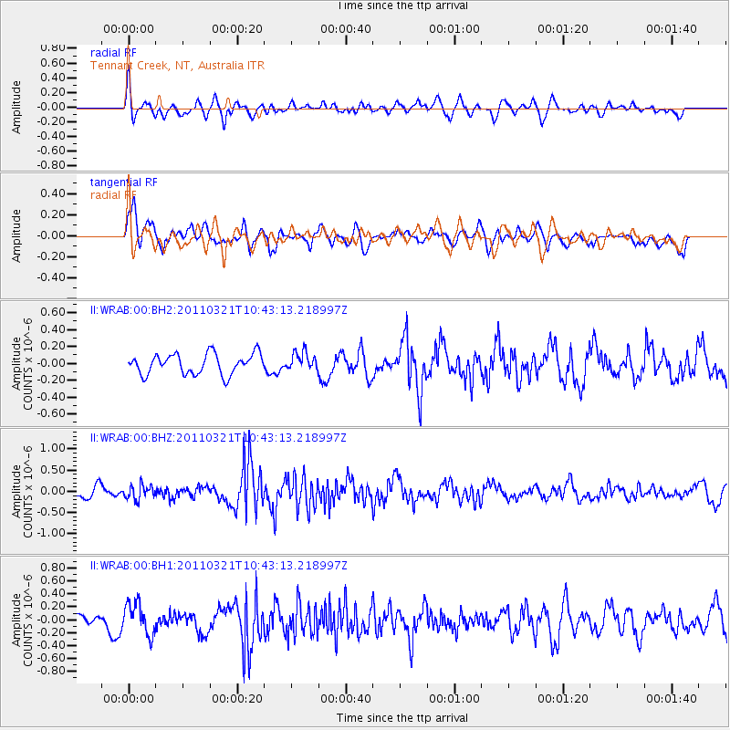
WRAB Tennant Creek, NT, Australia - Earthquake Result Viewer
*The percent match for this event was below the threshold and hence no stack was calculated.
| Earthquake location: |
Mindoro, Philippines |
| Earthquake latitude/longitude: |
13.9/120.6 |
| Earthquake time(UTC): |
2011/03/21 (080) 10:36:50 GMT |
| Earthquake Depth: |
102 km |
| Earthquake Magnitude: |
5.5 MW, 5.5 MW |
| Earthquake Catalog/Contributor: |
NEIC PDE/NEIC PDE-M |
|
| Network: |
II Global Seismograph Network (GSN - IRIS/IDA) |
| Station: |
WRAB Tennant Creek, NT, Australia |
| Lat/Lon: |
19.93 S/134.36 E |
| Elevation: |
366 m |
|
| Distance: |
36.3 deg |
| Az: |
157.718 deg |
| Baz: |
336.962 deg |
| Ray Param: |
$rayparam |
*The percent match for this event was below the threshold and hence was not used in the summary stack. |
|
| Radial Match: |
59.096775 % |
| Radial Bump: |
400 |
| Transverse Match: |
73.121445 % |
| Transverse Bump: |
400 |
| SOD ConfigId: |
558545 |
| Insert Time: |
2013-09-18 14:28:52.123 +0000 |
| GWidth: |
2.5 |
| Max Bumps: |
400 |
| Tol: |
0.001 |
|
Signal To Noise
| Channel | StoN | STA | LTA |
| II:WRAB:00:BHZ:20110321T10:43:13.218997Z | 1.5110744 | 1.6487134E-7 | 1.0910869E-7 |
| II:WRAB:00:BH1:20110321T10:43:13.218997Z | 2.615295 | 2.491836E-7 | 9.5279354E-8 |
| II:WRAB:00:BH2:20110321T10:43:13.218997Z | 0.87811804 | 1.06322595E-7 | 1.2108008E-7 |
| Arrivals |
| Ps | |
| PpPs | |
| PsPs/PpSs | |


