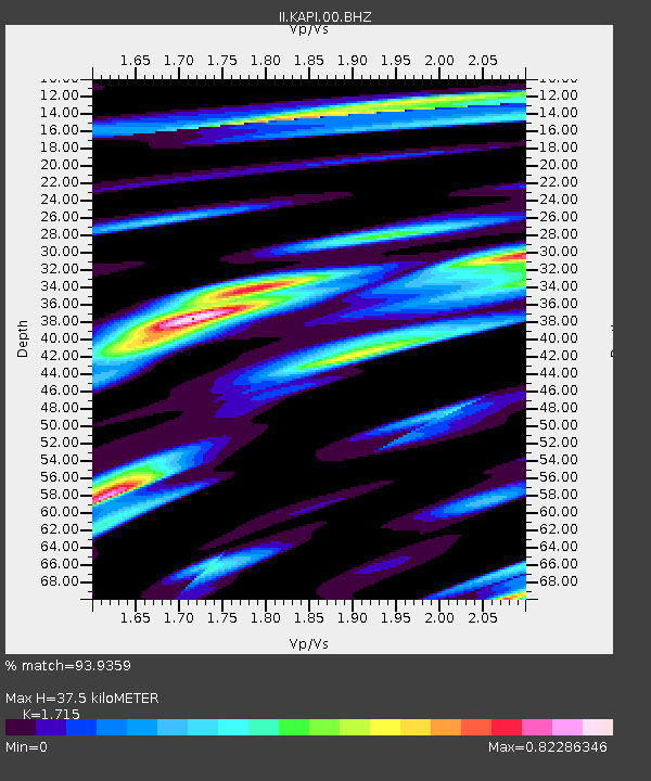
KAPI Kappang, Sulawesi, Indonesia - Earthquake Result Viewer

Earthquake location: Near East Coast Of Honshu, Japan
Earthquake latitude/longitude: 37.3/141.8
Earthquake time(UTC): 2011/03/22 (081) 09:19:06 GMT
Earthquake Depth: 31 km
Earthquake Magnitude: 6.1 MW, 5.9 MB, 5.9 MS, 6.0 MW
Earthquake Catalog/Contributor: NEIC PDE/NEIC PDE-M
Network: II Global Seismograph Network (GSN - IRIS/IDA)
Station: KAPI Kappang, Sulawesi, Indonesia
Lat/Lon: 5.01 S/119.75 E
Elevation: 300 m
Distance: 46.9 deg
Az: 210.814 deg
Baz: 24.199 deg
Ray Param: 0.07030972
Estimated Moho Depth: 37.5 km
Estimated Crust Vp/Vs: 1.72
Assumed Crust Vp: 6.343 km/s
Estimated Crust Vs: 3.699 km/s
Estimated Crust Poisson's Ratio: 0.24
Radial Match: 93.9359 %
Radial Bump: 400
Transverse Match: 92.06908 %
Transverse Bump: 400
SOD ConfigId: 558545
Insert Time: 2013-09-18 14:33:17.431 +0000
GWidth: 2.5
Max Bumps: 400
Tol: 0.001

Signal To Noise

ChannelStoNSTALTA
II:KAPI:00:BHZ:20110322T09:27:02.818989Z27.2308032.9316284E-61.07658536E-7
II:KAPI:00:BH1:20110322T09:27:02.818989Z18.7201291.7128573E-69.149816E-8
II:KAPI:00:BH2:20110322T09:27:02.818989Z9.1744898.939591E-79.743966E-8
Arrivals
Ps4.5 SECOND
PpPs15 SECOND
PsPs/PpSs20 SECOND