You are here: Home > Network List > CN - Canadian National Seismograph Network Stations List
> Station FRB IQALUIT, N.W.T. > Earthquake Result Viewer
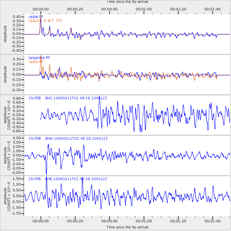
FRB IQALUIT, N.W.T. - Earthquake Result Viewer
*The percent match for this event was below the threshold and hence no stack was calculated.
| Earthquake location: |
Near East Coast Of Honshu, Japan |
| Earthquake latitude/longitude: |
35.5/140.9 |
| Earthquake time(UTC): |
1996/09/11 (255) 02:37:14 GMT |
| Earthquake Depth: |
55 km |
| Earthquake Magnitude: |
6.1 MB, 5.7 MS, 6.2 UNKNOWN, 6.1 MW |
| Earthquake Catalog/Contributor: |
WHDF/NEIC |
|
| Network: |
CN Canadian National Seismograph Network |
| Station: |
FRB IQALUIT, N.W.T. |
| Lat/Lon: |
63.75 N/68.55 W |
| Elevation: |
18 m |
|
| Distance: |
78.3 deg |
| Az: |
12.918 deg |
| Baz: |
335.796 deg |
| Ray Param: |
$rayparam |
*The percent match for this event was below the threshold and hence was not used in the summary stack. |
|
| Radial Match: |
75.58418 % |
| Radial Bump: |
400 |
| Transverse Match: |
67.29269 % |
| Transverse Bump: |
400 |
| SOD ConfigId: |
4480 |
| Insert Time: |
2010-02-27 05:54:50.513 +0000 |
| GWidth: |
2.5 |
| Max Bumps: |
400 |
| Tol: |
0.001 |
|
Signal To Noise
| Channel | StoN | STA | LTA |
| CN:FRB: :BHN:19960911T02:48:38.100012Z | 4.707167 | 1.4355622E-6 | 3.049737E-7 |
| CN:FRB: :BHE:19960911T02:48:38.100012Z | 2.5887265 | 5.483809E-7 | 2.1183423E-7 |
| CN:FRB: :BHZ:19960911T02:48:38.100012Z | 2.3688812 | 3.6264942E-7 | 1.530889E-7 |
| Arrivals |
| Ps | |
| PpPs | |
| PsPs/PpSs | |


