You are here: Home > Network List > TA - USArray Transportable Network (new EarthScope stations) Stations List
> Station W54A Cherokee Point, Campobello, SC, USA > Earthquake Result Viewer
W54A Cherokee Point, Campobello, SC, USA - Earthquake Result Viewer

| Earthquake location: |
Iceland |
| Earthquake latitude/longitude: |
64.8/-17.4 |
| Earthquake time(UTC): |
2014/09/03 (246) 03:09:56 GMT |
| Earthquake Depth: |
7.5 km |
| Earthquake Magnitude: |
5.4 MW |
| Earthquake Catalog/Contributor: |
ISC/ISC |
|
| Network: |
TA USArray Transportable Network (new EarthScope stations) |
| Station: |
W54A Cherokee Point, Campobello, SC, USA |
| Lat/Lon: |
35.09 N/82.19 W |
| Elevation: |
272 m |
|
| Distance: |
48.2 deg |
| Az: |
264.522 deg |
| Baz: |
31.309 deg |
| Ray Param: |
0.06953453 |
| Estimated Moho Depth: |
13.5 km |
| Estimated Crust Vp/Vs: |
1.62 |
| Assumed Crust Vp: |
6.35 km/s |
| Estimated Crust Vs: |
3.908 km/s |
| Estimated Crust Poisson's Ratio: |
0.20 |
|
| Radial Match: |
88.86304 % |
| Radial Bump: |
400 |
| Transverse Match: |
59.069065 % |
| Transverse Bump: |
400 |
| SOD ConfigId: |
3390531 |
| Insert Time: |
2019-04-13 19:15:59.168 +0000 |
| GWidth: |
2.5 |
| Max Bumps: |
400 |
| Tol: |
0.001 |
|
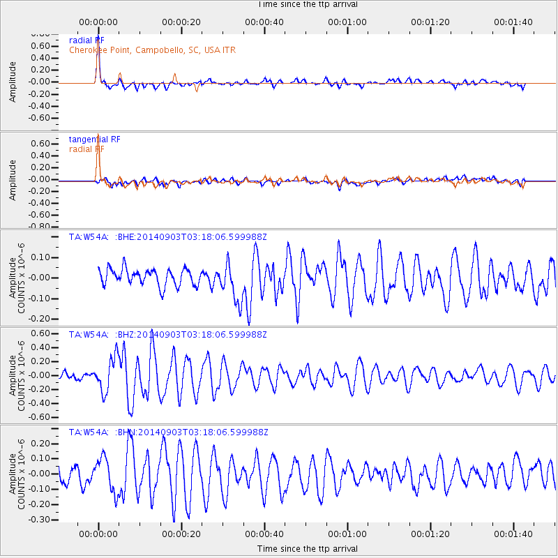
Signal To Noise
| Channel | StoN | STA | LTA |
| TA:W54A: :BHZ:20140903T03:18:06.599988Z | 5.5293694 | 2.4907072E-7 | 4.5045045E-8 |
| TA:W54A: :BHN:20140903T03:18:06.599988Z | 2.137035 | 1.16755004E-7 | 5.4634114E-8 |
| TA:W54A: :BHE:20140903T03:18:06.599988Z | 2.4148543 | 9.524345E-8 | 3.944066E-8 |
| Arrivals |
| Ps | 1.4 SECOND |
| PpPs | 5.2 SECOND |
| PsPs/PpSs | 6.6 SECOND |


