You are here: Home > Network List > II - Global Seismograph Network (GSN - IRIS/IDA) Stations List
> Station WRAB Tennant Creek, NT, Australia > Earthquake Result Viewer
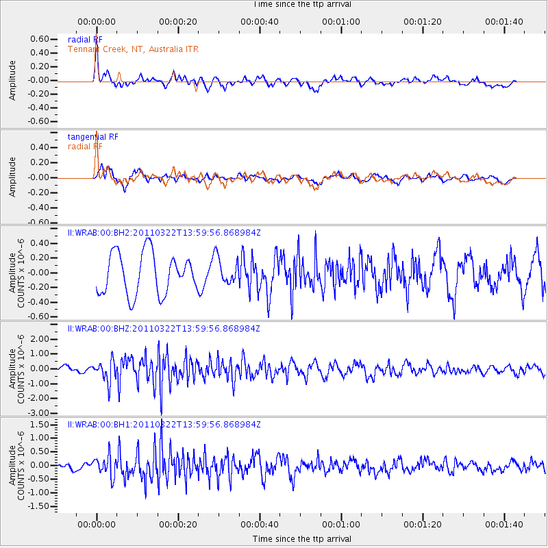
WRAB Tennant Creek, NT, Australia - Earthquake Result Viewer
*The percent match for this event was below the threshold and hence no stack was calculated.
| Earthquake location: |
Near East Coast Of Honshu, Japan |
| Earthquake latitude/longitude: |
35.8/141.5 |
| Earthquake time(UTC): |
2011/03/22 (081) 13:50:51 GMT |
| Earthquake Depth: |
20 km |
| Earthquake Magnitude: |
5.9 MW, 5.6 MS, 5.7 MW, 5.8 MB |
| Earthquake Catalog/Contributor: |
NEIC PDE/NEIC PDE-M |
|
| Network: |
II Global Seismograph Network (GSN - IRIS/IDA) |
| Station: |
WRAB Tennant Creek, NT, Australia |
| Lat/Lon: |
19.93 S/134.36 E |
| Elevation: |
366 m |
|
| Distance: |
55.8 deg |
| Az: |
188.18 deg |
| Baz: |
7.062 deg |
| Ray Param: |
$rayparam |
*The percent match for this event was below the threshold and hence was not used in the summary stack. |
|
| Radial Match: |
71.43232 % |
| Radial Bump: |
400 |
| Transverse Match: |
59.91588 % |
| Transverse Bump: |
400 |
| SOD ConfigId: |
558545 |
| Insert Time: |
2013-09-18 14:41:50.079 +0000 |
| GWidth: |
2.5 |
| Max Bumps: |
400 |
| Tol: |
0.001 |
|
Signal To Noise
| Channel | StoN | STA | LTA |
| II:WRAB:00:BHZ:20110322T13:59:56.868984Z | 3.4995055 | 7.1236974E-7 | 2.0356298E-7 |
| II:WRAB:00:BH1:20110322T13:59:56.868984Z | 3.0761936 | 3.766528E-7 | 1.2244118E-7 |
| II:WRAB:00:BH2:20110322T13:59:56.868984Z | 0.6397946 | 1.7807878E-7 | 2.7833744E-7 |
| Arrivals |
| Ps | |
| PpPs | |
| PsPs/PpSs | |


