You are here: Home > Network List > IU - Global Seismograph Network (GSN - IRIS/USGS) Stations List
> Station PMG Port Moresby, New Guinea > Earthquake Result Viewer
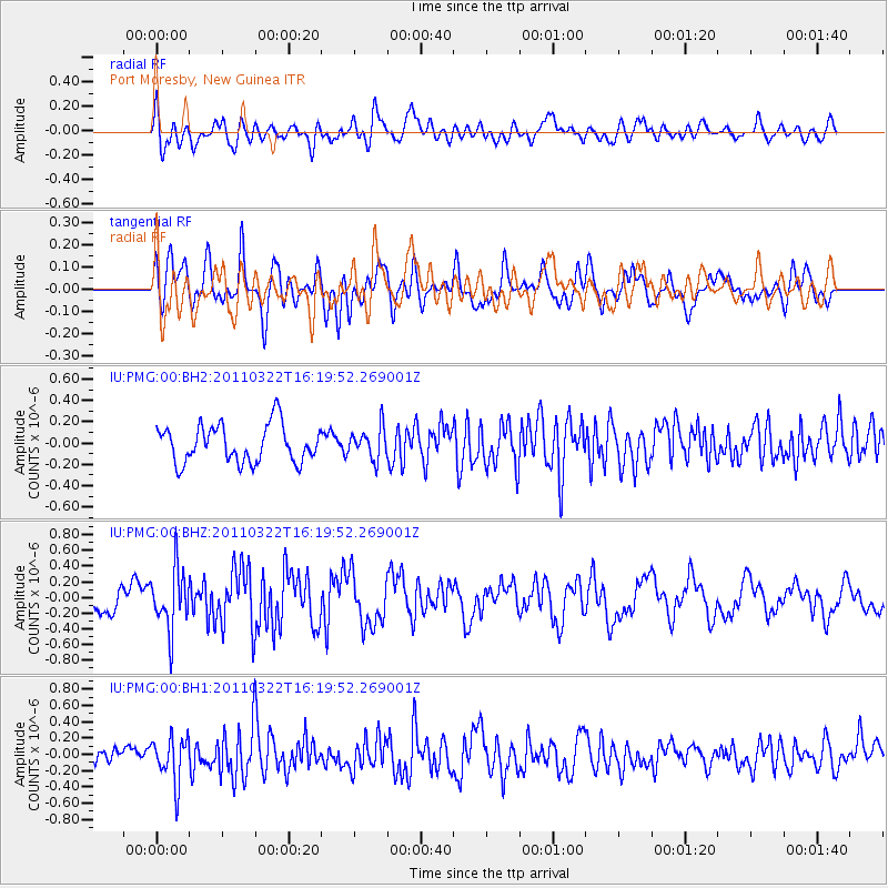
PMG Port Moresby, New Guinea - Earthquake Result Viewer
*The percent match for this event was below the threshold and hence no stack was calculated.
| Earthquake location: |
Near East Coast Of Honshu, Japan |
| Earthquake latitude/longitude: |
35.7/141.6 |
| Earthquake time(UTC): |
2011/03/22 (081) 16:12:09 GMT |
| Earthquake Depth: |
31 km |
| Earthquake Magnitude: |
5.6 MB, 5.2 MS, 5.3 MW |
| Earthquake Catalog/Contributor: |
WHDF/NEIC |
|
| Network: |
IU Global Seismograph Network (GSN - IRIS/USGS) |
| Station: |
PMG Port Moresby, New Guinea |
| Lat/Lon: |
9.40 S/147.16 E |
| Elevation: |
90 m |
|
| Distance: |
45.1 deg |
| Az: |
172.301 deg |
| Baz: |
353.654 deg |
| Ray Param: |
$rayparam |
*The percent match for this event was below the threshold and hence was not used in the summary stack. |
|
| Radial Match: |
60.806973 % |
| Radial Bump: |
400 |
| Transverse Match: |
52.866062 % |
| Transverse Bump: |
400 |
| SOD ConfigId: |
558545 |
| Insert Time: |
2013-09-18 14:44:57.626 +0000 |
| GWidth: |
2.5 |
| Max Bumps: |
400 |
| Tol: |
0.001 |
|
Signal To Noise
| Channel | StoN | STA | LTA |
| IU:PMG:00:BHZ:20110322T16:19:52.269001Z | 2.6987784 | 3.840046E-7 | 1.4228831E-7 |
| IU:PMG:00:BH1:20110322T16:19:52.269001Z | 2.24282 | 2.7650273E-7 | 1.2328353E-7 |
| IU:PMG:00:BH2:20110322T16:19:52.269001Z | 0.82882845 | 1.4533724E-7 | 1.7535261E-7 |
| Arrivals |
| Ps | |
| PpPs | |
| PsPs/PpSs | |


