You are here: Home > Network List > II - Global Seismograph Network (GSN - IRIS/IDA) Stations List
> Station PFO Pinon Flat, California, USA > Earthquake Result Viewer
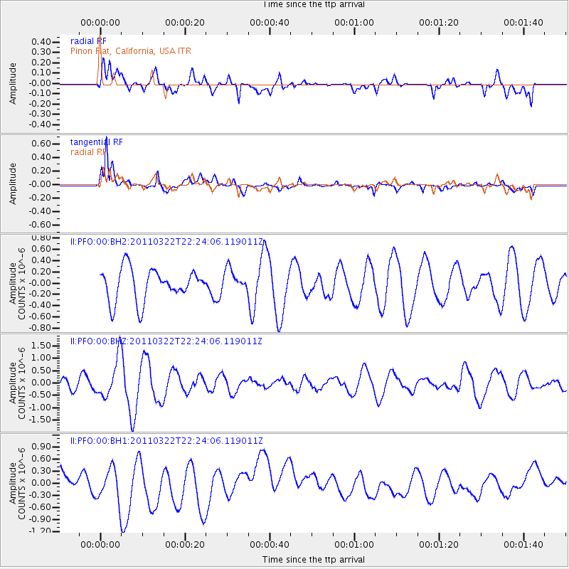
PFO Pinon Flat, California, USA - Earthquake Result Viewer
*The percent match for this event was below the threshold and hence no stack was calculated.
| Earthquake location: |
Eastern Honshu, Japan |
| Earthquake latitude/longitude: |
37.1/140.6 |
| Earthquake time(UTC): |
2011/03/22 (081) 22:12:31 GMT |
| Earthquake Depth: |
18 km |
| Earthquake Magnitude: |
5.5 MB, 5.4 MS, 5.7 MW, 5.5 MW |
| Earthquake Catalog/Contributor: |
WHDF/NEIC |
|
| Network: |
II Global Seismograph Network (GSN - IRIS/IDA) |
| Station: |
PFO Pinon Flat, California, USA |
| Lat/Lon: |
33.61 N/116.46 W |
| Elevation: |
1280 m |
|
| Distance: |
79.5 deg |
| Az: |
55.811 deg |
| Baz: |
307.546 deg |
| Ray Param: |
$rayparam |
*The percent match for this event was below the threshold and hence was not used in the summary stack. |
|
| Radial Match: |
54.752327 % |
| Radial Bump: |
400 |
| Transverse Match: |
76.712814 % |
| Transverse Bump: |
400 |
| SOD ConfigId: |
558545 |
| Insert Time: |
2013-09-18 14:45:44.085 +0000 |
| GWidth: |
2.5 |
| Max Bumps: |
400 |
| Tol: |
0.001 |
|
Signal To Noise
| Channel | StoN | STA | LTA |
| II:PFO:00:BHZ:20110322T22:24:06.119011Z | 2.0650666 | 8.09738E-7 | 3.9211233E-7 |
| II:PFO:00:BH1:20110322T22:24:06.119011Z | 1.4234836 | 4.188705E-7 | 2.9425735E-7 |
| II:PFO:00:BH2:20110322T22:24:06.119011Z | 0.72498757 | 2.0608182E-7 | 2.8425566E-7 |
| Arrivals |
| Ps | |
| PpPs | |
| PsPs/PpSs | |


