You are here: Home > Network List > II - Global Seismograph Network (GSN - IRIS/IDA) Stations List
> Station KAPI Kappang, Sulawesi, Indonesia > Earthquake Result Viewer
KAPI Kappang, Sulawesi, Indonesia - Earthquake Result Viewer
| Earthquake location: |
Myanmar |
| Earthquake latitude/longitude: |
20.7/99.8 |
| Earthquake time(UTC): |
2011/03/24 (083) 13:55:12 GMT |
| Earthquake Depth: |
8.0 km |
| Earthquake Magnitude: |
6.8 MW, 6.3 MB, 6.9 MW, 7.1 MS |
| Earthquake Catalog/Contributor: |
NEIC PDE/NEIC PDE-M |
|
| Network: |
II Global Seismograph Network (GSN - IRIS/IDA) |
| Station: |
KAPI Kappang, Sulawesi, Indonesia |
| Lat/Lon: |
5.01 S/119.75 E |
| Elevation: |
300 m |
|
| Distance: |
32.2 deg |
| Az: |
140.381 deg |
| Baz: |
323.178 deg |
| Ray Param: |
0.078767054 |
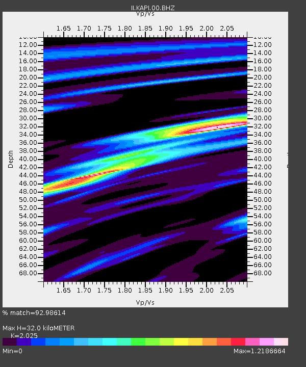
| Estimated Moho Depth: |
32.0 km |
| Estimated Crust Vp/Vs: |
2.03 |
| Assumed Crust Vp: |
6.343 km/s |
| Estimated Crust Vs: |
3.132 km/s |
| Estimated Crust Poisson's Ratio: |
0.34 |
|
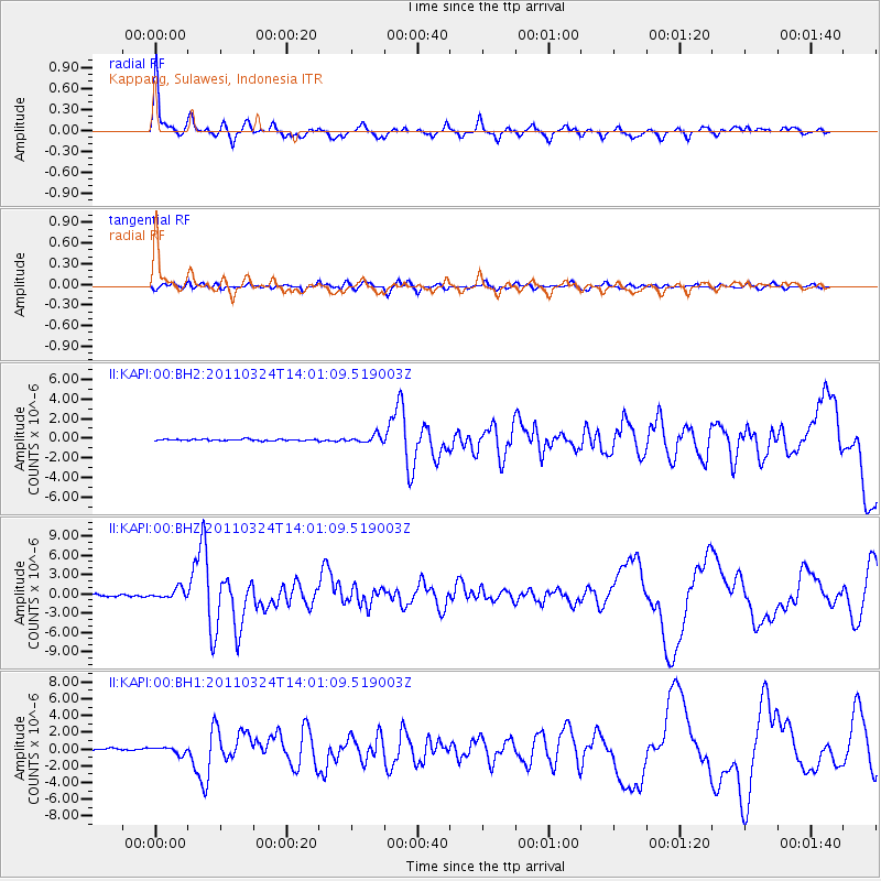
| Radial Match: |
92.98614 % |
| Radial Bump: |
400 |
| Transverse Match: |
69.911415 % |
| Transverse Bump: |
400 |
| SOD ConfigId: |
558545 |
| Insert Time: |
2013-09-18 14:54:09.323 +0000 |
| GWidth: |
2.5 |
| Max Bumps: |
400 |
| Tol: |
0.001 |
|
Signal To Noise
| Channel | StoN | STA | LTA |
| II:KAPI:00:BHZ:20110324T14:01:09.519003Z | 5.3143396 | 7.495575E-7 | 1.4104434E-7 |
| II:KAPI:00:BH1:20110324T14:01:09.519003Z | 5.347694 | 4.159685E-7 | 7.778465E-8 |
| II:KAPI:00:BH2:20110324T14:01:09.519003Z | 5.050285 | 3.8055214E-7 | 7.535261E-8 |
| Arrivals |
| Ps | 5.5 SECOND |
| PpPs | 14 SECOND |
| PsPs/PpSs | 20 SECOND |


