You are here: Home > Network List > II - Global Seismograph Network (GSN - IRIS/IDA) Stations List
> Station WRAB Tennant Creek, NT, Australia > Earthquake Result Viewer
WRAB Tennant Creek, NT, Australia - Earthquake Result Viewer
| Earthquake location: |
Myanmar |
| Earthquake latitude/longitude: |
20.7/99.8 |
| Earthquake time(UTC): |
2011/03/24 (083) 13:55:12 GMT |
| Earthquake Depth: |
8.0 km |
| Earthquake Magnitude: |
6.8 MW, 6.3 MB, 6.9 MW, 7.1 MS |
| Earthquake Catalog/Contributor: |
NEIC PDE/NEIC PDE-M |
|
| Network: |
II Global Seismograph Network (GSN - IRIS/IDA) |
| Station: |
WRAB Tennant Creek, NT, Australia |
| Lat/Lon: |
19.93 S/134.36 E |
| Elevation: |
366 m |
|
| Distance: |
52.7 deg |
| Az: |
137.86 deg |
| Baz: |
318.108 deg |
| Ray Param: |
0.06662546 |
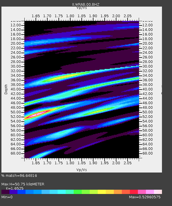
| Estimated Moho Depth: |
50.75 km |
| Estimated Crust Vp/Vs: |
1.65 |
| Assumed Crust Vp: |
6.642 km/s |
| Estimated Crust Vs: |
4.019 km/s |
| Estimated Crust Poisson's Ratio: |
0.21 |
|
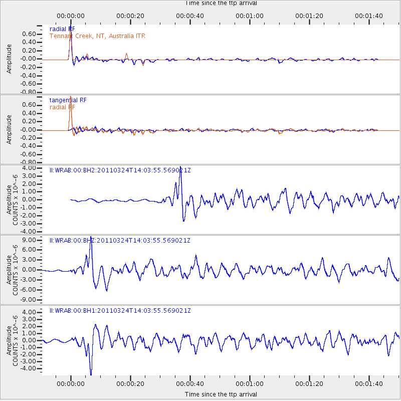
| Radial Match: |
96.64816 % |
| Radial Bump: |
238 |
| Transverse Match: |
68.00075 % |
| Transverse Bump: |
400 |
| SOD ConfigId: |
558545 |
| Insert Time: |
2013-09-18 14:54:21.390 +0000 |
| GWidth: |
2.5 |
| Max Bumps: |
400 |
| Tol: |
0.001 |
|
Signal To Noise
| Channel | StoN | STA | LTA |
| II:WRAB:00:BHZ:20110324T14:03:55.569021Z | 4.491751 | 7.7682563E-7 | 1.7294494E-7 |
| II:WRAB:00:BH1:20110324T14:03:55.569021Z | 2.090197 | 4.1676725E-7 | 1.9939137E-7 |
| II:WRAB:00:BH2:20110324T14:03:55.569021Z | 3.524454 | 3.6636857E-7 | 1.0395044E-7 |
| Arrivals |
| Ps | 5.3 SECOND |
| PpPs | 19 SECOND |
| PsPs/PpSs | 24 SECOND |


