You are here: Home > Network List > IU - Global Seismograph Network (GSN - IRIS/USGS) Stations List
> Station ANTO Ankara, Turkey > Earthquake Result Viewer
ANTO Ankara, Turkey - Earthquake Result Viewer
| Earthquake location: |
Myanmar |
| Earthquake latitude/longitude: |
20.7/99.8 |
| Earthquake time(UTC): |
2011/03/24 (083) 13:55:12 GMT |
| Earthquake Depth: |
8.0 km |
| Earthquake Magnitude: |
6.8 MW, 6.3 MB, 6.9 MW, 7.1 MS |
| Earthquake Catalog/Contributor: |
NEIC PDE/NEIC PDE-M |
|
| Network: |
IU Global Seismograph Network (GSN - IRIS/USGS) |
| Station: |
ANTO Ankara, Turkey |
| Lat/Lon: |
39.87 N/32.79 E |
| Elevation: |
1090 m |
|
| Distance: |
59.6 deg |
| Az: |
304.791 deg |
| Baz: |
87.544 deg |
| Ray Param: |
0.062060952 |
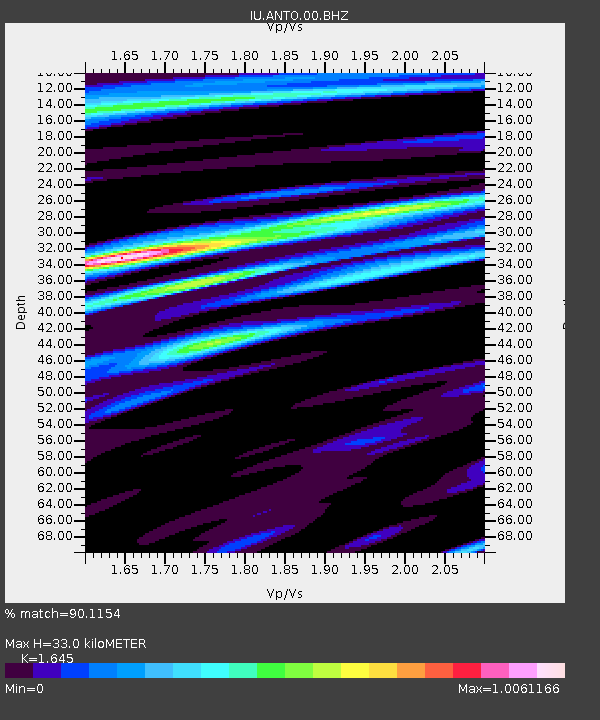
| Estimated Moho Depth: |
33.0 km |
| Estimated Crust Vp/Vs: |
1.64 |
| Assumed Crust Vp: |
6.159 km/s |
| Estimated Crust Vs: |
3.744 km/s |
| Estimated Crust Poisson's Ratio: |
0.21 |
|
| Radial Match: |
90.1154 % |
| Radial Bump: |
400 |
| Transverse Match: |
77.70417 % |
| Transverse Bump: |
400 |
| SOD ConfigId: |
558545 |
| Insert Time: |
2013-09-18 14:54:28.130 +0000 |
| GWidth: |
2.5 |
| Max Bumps: |
400 |
| Tol: |
0.001 |
|

Signal To Noise
| Channel | StoN | STA | LTA |
| IU:ANTO:00:BHZ:20110324T14:04:45.418997Z | 7.061516 | 8.6620685E-7 | 1.2266585E-7 |
| IU:ANTO:00:BH1:20110324T14:04:45.418997Z | 0.70078796 | 9.133642E-8 | 1.3033389E-7 |
| IU:ANTO:00:BH2:20110324T14:04:45.418997Z | 3.6946964 | 3.3467091E-7 | 9.058144E-8 |
| Arrivals |
| Ps | 3.6 SECOND |
| PpPs | 14 SECOND |
| PsPs/PpSs | 17 SECOND |


