You are here: Home > Network List > IU - Global Seismograph Network (GSN - IRIS/USGS) Stations List
> Station GNI Garni, Armenia > Earthquake Result Viewer
GNI Garni, Armenia - Earthquake Result Viewer
| Earthquake location: |
Myanmar |
| Earthquake latitude/longitude: |
20.7/99.8 |
| Earthquake time(UTC): |
2011/03/24 (083) 13:55:12 GMT |
| Earthquake Depth: |
8.0 km |
| Earthquake Magnitude: |
6.8 MW, 6.3 MB, 6.9 MW, 7.1 MS |
| Earthquake Catalog/Contributor: |
NEIC PDE/NEIC PDE-M |
|
| Network: |
IU Global Seismograph Network (GSN - IRIS/USGS) |
| Station: |
GNI Garni, Armenia |
| Lat/Lon: |
40.15 N/44.74 E |
| Elevation: |
1609 m |
|
| Distance: |
50.5 deg |
| Az: |
305.435 deg |
| Baz: |
95.581 deg |
| Ray Param: |
0.068035334 |
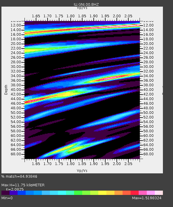
| Estimated Moho Depth: |
11.75 km |
| Estimated Crust Vp/Vs: |
2.08 |
| Assumed Crust Vp: |
6.291 km/s |
| Estimated Crust Vs: |
3.021 km/s |
| Estimated Crust Poisson's Ratio: |
0.35 |
|
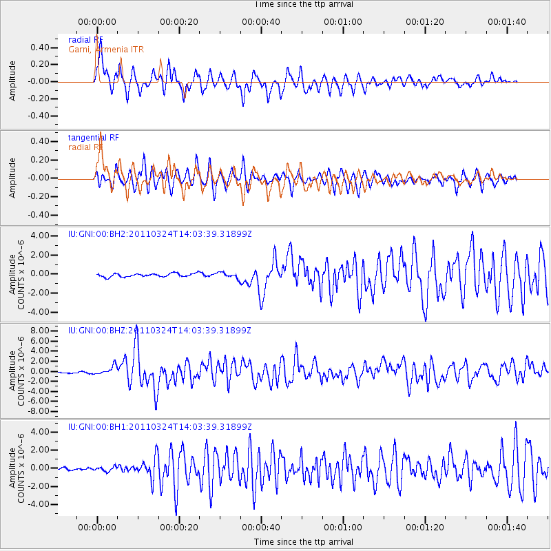
| Radial Match: |
84.93846 % |
| Radial Bump: |
400 |
| Transverse Match: |
73.39313 % |
| Transverse Bump: |
400 |
| SOD ConfigId: |
558545 |
| Insert Time: |
2013-09-18 14:54:36.254 +0000 |
| GWidth: |
2.5 |
| Max Bumps: |
400 |
| Tol: |
0.001 |
|
Signal To Noise
| Channel | StoN | STA | LTA |
| IU:GNI:00:BHZ:20110324T14:03:39.31899Z | 7.753066 | 9.188834E-7 | 1.1851871E-7 |
| IU:GNI:00:BH1:20110324T14:03:39.31899Z | 1.7250067 | 2.4061072E-7 | 1.3948393E-7 |
| IU:GNI:00:BH2:20110324T14:03:39.31899Z | 1.7434394 | 3.0313163E-7 | 1.7386989E-7 |
| Arrivals |
| Ps | 2.1 SECOND |
| PpPs | 5.5 SECOND |
| PsPs/PpSs | 7.6 SECOND |


