You are here: Home > Network List > IU - Global Seismograph Network (GSN - IRIS/USGS) Stations List
> Station PMG Port Moresby, New Guinea > Earthquake Result Viewer
PMG Port Moresby, New Guinea - Earthquake Result Viewer
| Earthquake location: |
Myanmar |
| Earthquake latitude/longitude: |
20.7/99.8 |
| Earthquake time(UTC): |
2011/03/24 (083) 13:55:12 GMT |
| Earthquake Depth: |
8.0 km |
| Earthquake Magnitude: |
6.8 MW, 6.3 MB, 6.9 MW, 7.1 MS |
| Earthquake Catalog/Contributor: |
NEIC PDE/NEIC PDE-M |
|
| Network: |
IU Global Seismograph Network (GSN - IRIS/USGS) |
| Station: |
PMG Port Moresby, New Guinea |
| Lat/Lon: |
9.40 S/147.16 E |
| Elevation: |
90 m |
|
| Distance: |
55.3 deg |
| Az: |
118.063 deg |
| Baz: |
303.141 deg |
| Ray Param: |
0.06487917 |
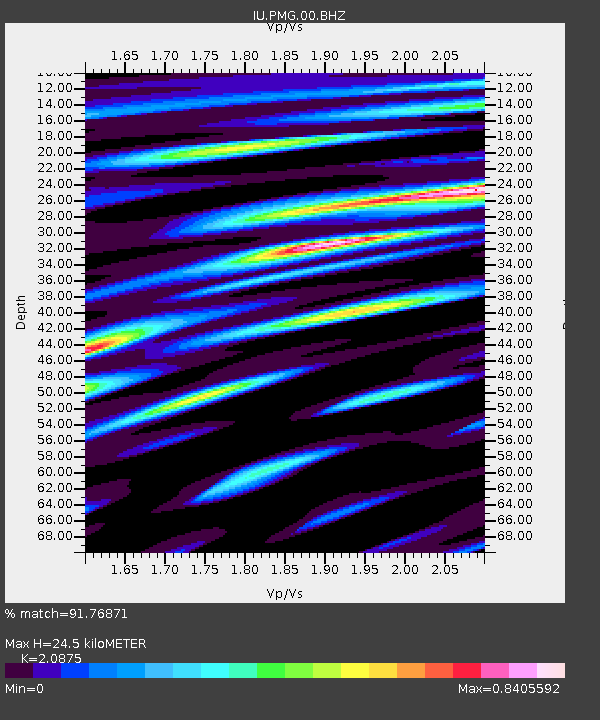
| Estimated Moho Depth: |
24.5 km |
| Estimated Crust Vp/Vs: |
2.09 |
| Assumed Crust Vp: |
6.122 km/s |
| Estimated Crust Vs: |
2.933 km/s |
| Estimated Crust Poisson's Ratio: |
0.35 |
|
| Radial Match: |
91.76871 % |
| Radial Bump: |
400 |
| Transverse Match: |
83.236145 % |
| Transverse Bump: |
400 |
| SOD ConfigId: |
558545 |
| Insert Time: |
2013-09-18 14:55:12.413 +0000 |
| GWidth: |
2.5 |
| Max Bumps: |
400 |
| Tol: |
0.001 |
|
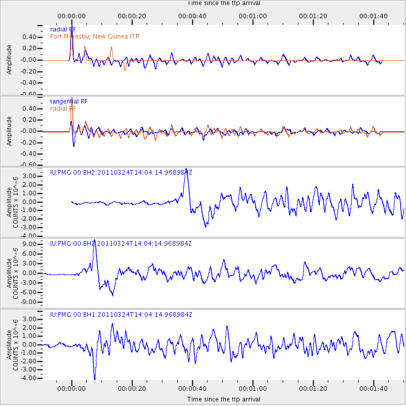
Signal To Noise
| Channel | StoN | STA | LTA |
| IU:PMG:00:BHZ:20110324T14:04:14.968984Z | 5.8559337 | 7.4792274E-7 | 1.277205E-7 |
| IU:PMG:00:BH1:20110324T14:04:14.968984Z | 1.8116217 | 2.340222E-7 | 1.2917829E-7 |
| IU:PMG:00:BH2:20110324T14:04:14.968984Z | 1.9966486 | 2.1618436E-7 | 1.0827362E-7 |
| Arrivals |
| Ps | 4.5 SECOND |
| PpPs | 12 SECOND |
| PsPs/PpSs | 16 SECOND |


