You are here: Home > Network List > IU - Global Seismograph Network (GSN - IRIS/USGS) Stations List
> Station GNI Garni, Armenia > Earthquake Result Viewer
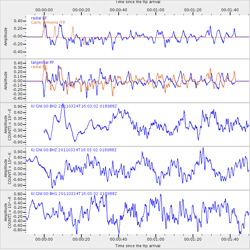
GNI Garni, Armenia - Earthquake Result Viewer
*The percent match for this event was below the threshold and hence no stack was calculated.
| Earthquake location: |
Myanmar |
| Earthquake latitude/longitude: |
20.6/99.8 |
| Earthquake time(UTC): |
2011/03/24 (083) 15:54:35 GMT |
| Earthquake Depth: |
10 km |
| Earthquake Magnitude: |
5.7 MW |
| Earthquake Catalog/Contributor: |
NEIC PDE/NEIC PDE-M |
|
| Network: |
IU Global Seismograph Network (GSN - IRIS/USGS) |
| Station: |
GNI Garni, Armenia |
| Lat/Lon: |
40.15 N/44.74 E |
| Elevation: |
1609 m |
|
| Distance: |
50.5 deg |
| Az: |
305.465 deg |
| Baz: |
95.656 deg |
| Ray Param: |
$rayparam |
*The percent match for this event was below the threshold and hence was not used in the summary stack. |
|
| Radial Match: |
52.98962 % |
| Radial Bump: |
400 |
| Transverse Match: |
58.258007 % |
| Transverse Bump: |
400 |
| SOD ConfigId: |
558545 |
| Insert Time: |
2013-09-18 14:56:10.401 +0000 |
| GWidth: |
2.5 |
| Max Bumps: |
400 |
| Tol: |
0.001 |
|
Signal To Noise
| Channel | StoN | STA | LTA |
| IU:GNI:00:BHZ:20110324T16:03:02.018988Z | 1.4234056 | 4.7610578E-7 | 3.3448356E-7 |
| IU:GNI:00:BH1:20110324T16:03:02.018988Z | 0.483449 | 1.840167E-7 | 3.806331E-7 |
| IU:GNI:00:BH2:20110324T16:03:02.018988Z | 0.1770121 | 7.884693E-8 | 4.4543245E-7 |
| Arrivals |
| Ps | |
| PpPs | |
| PsPs/PpSs | |


