You are here: Home > Network List > IU - Global Seismograph Network (GSN - IRIS/USGS) Stations List
> Station HNR Honiara, Solomon Islands > Earthquake Result Viewer
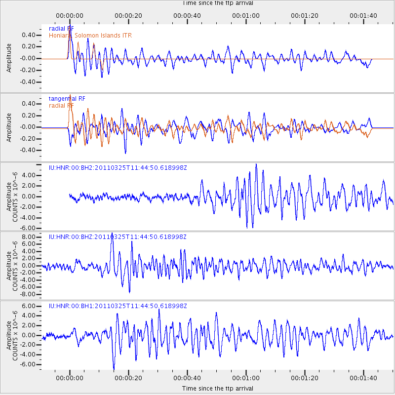
HNR Honiara, Solomon Islands - Earthquake Result Viewer
*The percent match for this event was below the threshold and hence no stack was calculated.
| Earthquake location: |
Near East Coast Of Honshu, Japan |
| Earthquake latitude/longitude: |
38.8/141.9 |
| Earthquake time(UTC): |
2011/03/25 (084) 11:36:24 GMT |
| Earthquake Depth: |
39 km |
| Earthquake Magnitude: |
6.2 MW, 5.9 MS, 6.1 MW, 6.2 MB |
| Earthquake Catalog/Contributor: |
NEIC PDE/NEIC PDE-M |
|
| Network: |
IU Global Seismograph Network (GSN - IRIS/USGS) |
| Station: |
HNR Honiara, Solomon Islands |
| Lat/Lon: |
9.44 S/159.95 E |
| Elevation: |
100 m |
|
| Distance: |
50.8 deg |
| Az: |
156.754 deg |
| Baz: |
341.778 deg |
| Ray Param: |
$rayparam |
*The percent match for this event was below the threshold and hence was not used in the summary stack. |
|
| Radial Match: |
69.07708 % |
| Radial Bump: |
400 |
| Transverse Match: |
79.154434 % |
| Transverse Bump: |
400 |
| SOD ConfigId: |
558545 |
| Insert Time: |
2013-09-18 14:58:13.941 +0000 |
| GWidth: |
2.5 |
| Max Bumps: |
400 |
| Tol: |
0.001 |
|
Signal To Noise
| Channel | StoN | STA | LTA |
| IU:HNR:00:BHZ:20110325T11:44:50.618998Z | 2.7235415 | 1.0626088E-6 | 3.9015703E-7 |
| IU:HNR:00:BH1:20110325T11:44:50.618998Z | 2.9961722 | 9.352961E-7 | 3.1216365E-7 |
| IU:HNR:00:BH2:20110325T11:44:50.618998Z | 0.92340297 | 3.6875903E-7 | 3.993479E-7 |
| Arrivals |
| Ps | |
| PpPs | |
| PsPs/PpSs | |


