You are here: Home > Network List > IU - Global Seismograph Network (GSN - IRIS/USGS) Stations List
> Station RSSD Black Hills, South Dakota, USA > Earthquake Result Viewer
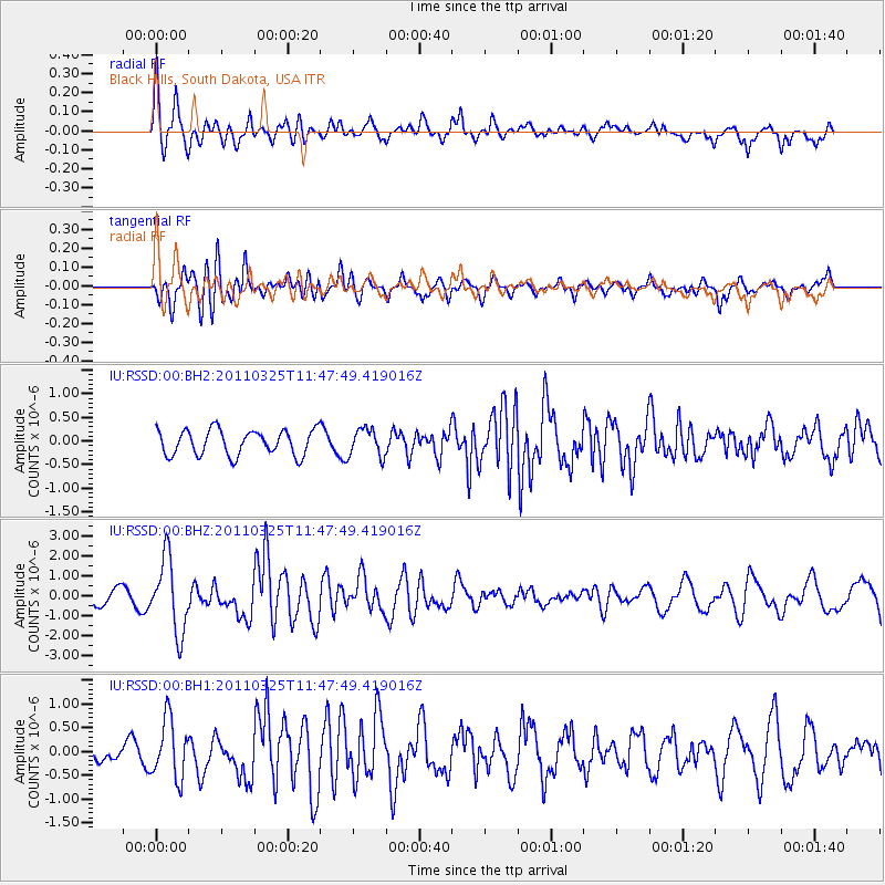
RSSD Black Hills, South Dakota, USA - Earthquake Result Viewer
*The percent match for this event was below the threshold and hence no stack was calculated.
| Earthquake location: |
Near East Coast Of Honshu, Japan |
| Earthquake latitude/longitude: |
38.8/141.9 |
| Earthquake time(UTC): |
2011/03/25 (084) 11:36:24 GMT |
| Earthquake Depth: |
39 km |
| Earthquake Magnitude: |
6.2 MW, 5.9 MS, 6.1 MW, 6.2 MB |
| Earthquake Catalog/Contributor: |
NEIC PDE/NEIC PDE-M |
|
| Network: |
IU Global Seismograph Network (GSN - IRIS/USGS) |
| Station: |
RSSD Black Hills, South Dakota, USA |
| Lat/Lon: |
44.12 N/104.04 W |
| Elevation: |
2090 m |
|
| Distance: |
78.3 deg |
| Az: |
42.181 deg |
| Baz: |
313.213 deg |
| Ray Param: |
$rayparam |
*The percent match for this event was below the threshold and hence was not used in the summary stack. |
|
| Radial Match: |
71.88936 % |
| Radial Bump: |
400 |
| Transverse Match: |
68.3432 % |
| Transverse Bump: |
400 |
| SOD ConfigId: |
558545 |
| Insert Time: |
2013-09-18 14:58:43.351 +0000 |
| GWidth: |
2.5 |
| Max Bumps: |
400 |
| Tol: |
0.001 |
|
Signal To Noise
| Channel | StoN | STA | LTA |
| IU:RSSD:00:BHZ:20110325T11:47:49.419016Z | 3.3840616 | 1.8299246E-6 | 5.4074803E-7 |
| IU:RSSD:00:BH1:20110325T11:47:49.419016Z | 2.0438364 | 6.172909E-7 | 3.020256E-7 |
| IU:RSSD:00:BH2:20110325T11:47:49.419016Z | 1.1047349 | 2.9548045E-7 | 2.6746727E-7 |
| Arrivals |
| Ps | |
| PpPs | |
| PsPs/PpSs | |


