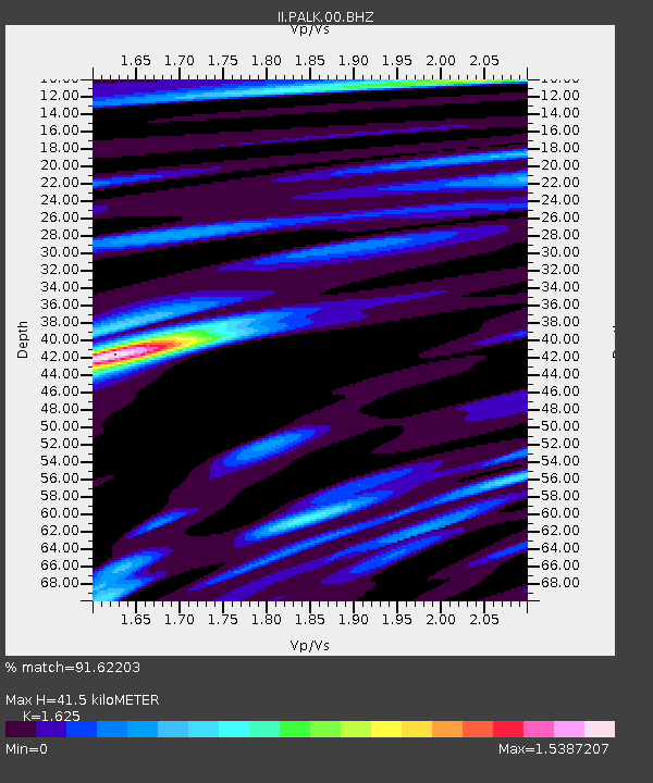
PALK Pallekele, Sri Lanka - Earthquake Result Viewer
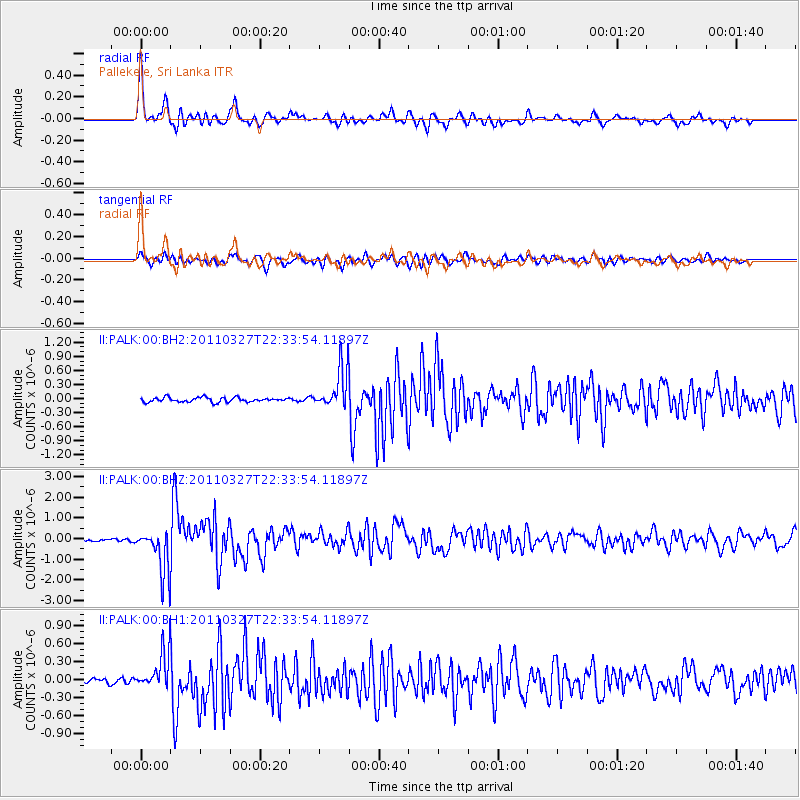
Earthquake location: Near East Coast Of Honshu, Japan
Earthquake latitude/longitude: 38.4/142.0
Earthquake time(UTC): 2011/03/27 (086) 22:23:58 GMT
Earthquake Depth: 19 km
Earthquake Magnitude: 6.1 MW, 6.1 MS, 6.2 MW, 6.3 MB
Earthquake Catalog/Contributor: NEIC PDE/NEIC PDE-M
Network: II Global Seismograph Network (GSN - IRIS/IDA)
Station: PALK Pallekele, Sri Lanka
Lat/Lon: 7.27 N/80.70 E
Elevation: 460 m
Distance: 63.1 deg
Az: 257.312 deg
Baz: 50.58 deg
Ray Param: 0.05975673
Estimated Moho Depth: 41.5 km
Estimated Crust Vp/Vs: 1.62
Assumed Crust Vp: 6.545 km/s
Estimated Crust Vs: 4.028 km/s
Estimated Crust Poisson's Ratio: 0.20
Radial Match: 91.62203 %
Radial Bump: 400
Transverse Match: 78.85889 %
Transverse Bump: 400
SOD ConfigId: 558545
Insert Time: 2013-09-18 15:05:53.060 +0000
GWidth: 2.5
Max Bumps: 400
Tol: 0.001

Signal To Noise

ChannelStoNSTALTA
II:PALK:00:BHZ:20110327T22:33:54.11897Z26.792991.1114489E-64.1482824E-8
II:PALK:00:BH1:20110327T22:33:54.11897Z5.90534733.2171454E-75.4478512E-8
II:PALK:00:BH2:20110327T22:33:54.11897Z8.9194024.2763497E-74.7944354E-8
Arrivals
Ps4.2 SECOND
PpPs16 SECOND
PsPs/PpSs20 SECOND