ANTO Ankara, Turkey - Earthquake Result Viewer
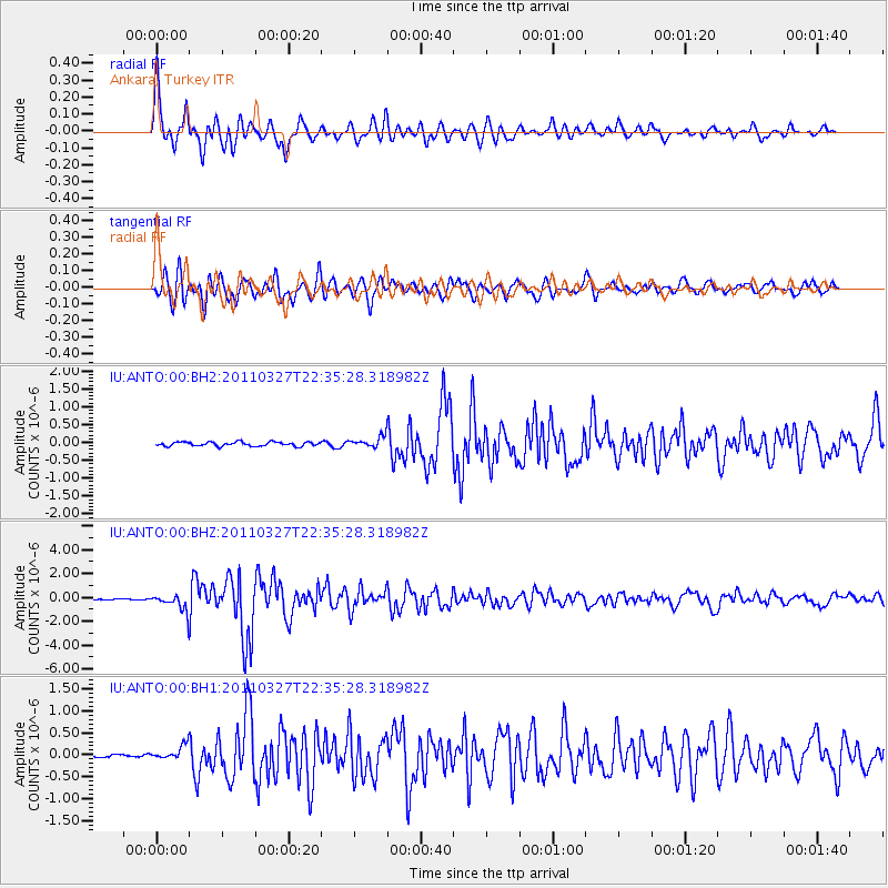
Earthquake location: Near East Coast Of Honshu, Japan
Earthquake latitude/longitude: 38.4/142.0
Earthquake time(UTC): 2011/03/27 (086) 22:23:58 GMT
Earthquake Depth: 19 km
Earthquake Magnitude: 6.1 MW, 6.1 MS, 6.2 MW, 6.3 MB
Earthquake Catalog/Contributor: NEIC PDE/NEIC PDE-M
Network: IU Global Seismograph Network (GSN - IRIS/USGS)
Station: ANTO Ankara, Turkey
Lat/Lon: 39.87 N/32.79 E
Elevation: 1090 m
Distance: 78.7 deg
Az: 312.172 deg
Baz: 49.154 deg
Ray Param: 0.049452405
Estimated Moho Depth: 31.25 km
Estimated Crust Vp/Vs: 1.86
Assumed Crust Vp: 6.159 km/s
Estimated Crust Vs: 3.307 km/s
Estimated Crust Poisson's Ratio: 0.30
Radial Match: 93.77649 %
Radial Bump: 400
Transverse Match: 89.73461 %
Transverse Bump: 400
SOD ConfigId: 558545
Insert Time: 2013-09-18 15:06:12.178 +0000
GWidth: 2.5
Max Bumps: 400
Tol: 0.001

Signal To Noise

ChannelStoNSTALTA
IU:ANTO:00:BHZ:20110327T22:35:28.318982Z8.6416966.625026E-77.66635E-8
IU:ANTO:00:BH1:20110327T22:35:28.318982Z2.79177621.5819883E-75.6666014E-8
IU:ANTO:00:BH2:20110327T22:35:28.318982Z2.63525581.46844E-75.5722865E-8
Arrivals
Ps4.5 SECOND
PpPs14 SECOND
PsPs/PpSs19 SECOND