You are here: Home > Network List > IU - Global Seismograph Network (GSN - IRIS/USGS) Stations List
> Station JOHN Johnston Island, USA > Earthquake Result Viewer
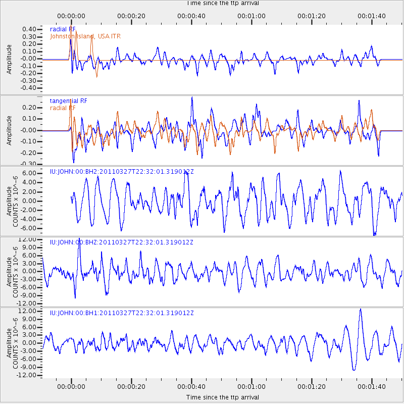
JOHN Johnston Island, USA - Earthquake Result Viewer
*The percent match for this event was below the threshold and hence no stack was calculated.
| Earthquake location: |
Near East Coast Of Honshu, Japan |
| Earthquake latitude/longitude: |
38.4/142.0 |
| Earthquake time(UTC): |
2011/03/27 (086) 22:23:58 GMT |
| Earthquake Depth: |
19 km |
| Earthquake Magnitude: |
6.1 MW, 6.1 MS, 6.2 MW, 6.3 MB |
| Earthquake Catalog/Contributor: |
NEIC PDE/NEIC PDE-M |
|
| Network: |
IU Global Seismograph Network (GSN - IRIS/USGS) |
| Station: |
JOHN Johnston Island, USA |
| Lat/Lon: |
16.73 N/169.53 W |
| Elevation: |
2.0 m |
|
| Distance: |
47.5 deg |
| Az: |
103.215 deg |
| Baz: |
307.048 deg |
| Ray Param: |
$rayparam |
*The percent match for this event was below the threshold and hence was not used in the summary stack. |
|
| Radial Match: |
49.46322 % |
| Radial Bump: |
400 |
| Transverse Match: |
74.42781 % |
| Transverse Bump: |
400 |
| SOD ConfigId: |
558545 |
| Insert Time: |
2013-09-18 15:06:31.633 +0000 |
| GWidth: |
2.5 |
| Max Bumps: |
400 |
| Tol: |
0.001 |
|
Signal To Noise
| Channel | StoN | STA | LTA |
| IU:JOHN:00:BHZ:20110327T22:32:01.319012Z | 1.9168109 | 4.894397E-6 | 2.5534064E-6 |
| IU:JOHN:00:BH1:20110327T22:32:01.319012Z | 1.0903624 | 1.8640372E-6 | 1.7095576E-6 |
| IU:JOHN:00:BH2:20110327T22:32:01.319012Z | 0.65416956 | 2.0247637E-6 | 3.0951667E-6 |
| Arrivals |
| Ps | |
| PpPs | |
| PsPs/PpSs | |


