You are here: Home > Network List > IU - Global Seismograph Network (GSN - IRIS/USGS) Stations List
> Station POHA Pohakuloa, Hawaii, USA > Earthquake Result Viewer
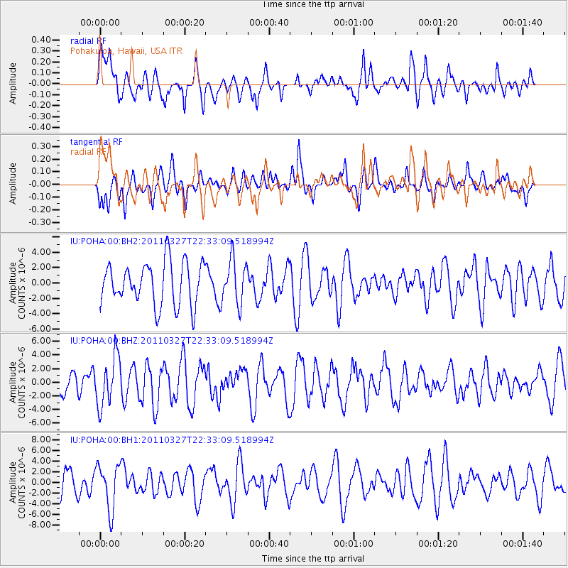
POHA Pohakuloa, Hawaii, USA - Earthquake Result Viewer
*The percent match for this event was below the threshold and hence no stack was calculated.
| Earthquake location: |
Near East Coast Of Honshu, Japan |
| Earthquake latitude/longitude: |
38.4/142.0 |
| Earthquake time(UTC): |
2011/03/27 (086) 22:23:58 GMT |
| Earthquake Depth: |
19 km |
| Earthquake Magnitude: |
6.1 MW, 6.1 MS, 6.2 MW, 6.3 MB |
| Earthquake Catalog/Contributor: |
NEIC PDE/NEIC PDE-M |
|
| Network: |
IU Global Seismograph Network (GSN - IRIS/USGS) |
| Station: |
POHA Pohakuloa, Hawaii, USA |
| Lat/Lon: |
19.76 N/155.53 W |
| Elevation: |
1990 m |
|
| Distance: |
56.6 deg |
| Az: |
90.38 deg |
| Baz: |
303.484 deg |
| Ray Param: |
$rayparam |
*The percent match for this event was below the threshold and hence was not used in the summary stack. |
|
| Radial Match: |
57.1152 % |
| Radial Bump: |
400 |
| Transverse Match: |
42.35322 % |
| Transverse Bump: |
400 |
| SOD ConfigId: |
558545 |
| Insert Time: |
2013-09-18 15:06:49.972 +0000 |
| GWidth: |
2.5 |
| Max Bumps: |
400 |
| Tol: |
0.001 |
|
Signal To Noise
| Channel | StoN | STA | LTA |
| IU:POHA:00:BHZ:20110327T22:33:09.518994Z | 2.1866612 | 3.6995093E-6 | 1.691853E-6 |
| IU:POHA:00:BH1:20110327T22:33:09.518994Z | 1.7074789 | 4.3587456E-6 | 2.5527377E-6 |
| IU:POHA:00:BH2:20110327T22:33:09.518994Z | 1.031728 | 2.862883E-6 | 2.7748426E-6 |
| Arrivals |
| Ps | |
| PpPs | |
| PsPs/PpSs | |


