You are here: Home > Network List > IU - Global Seismograph Network (GSN - IRIS/USGS) Stations List
> Station JOHN Johnston Island, USA > Earthquake Result Viewer
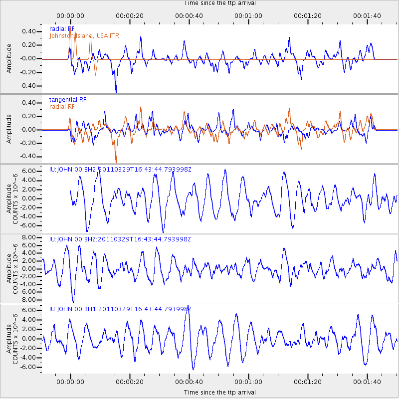
JOHN Johnston Island, USA - Earthquake Result Viewer
*The percent match for this event was below the threshold and hence no stack was calculated.
| Earthquake location: |
Off East Coast Of Honshu, Japan |
| Earthquake latitude/longitude: |
39.6/143.5 |
| Earthquake time(UTC): |
2011/03/29 (088) 16:35:49 GMT |
| Earthquake Depth: |
25 km |
| Earthquake Magnitude: |
5.5 MW |
| Earthquake Catalog/Contributor: |
NEIC PDE/NEIC PDE-M |
|
| Network: |
IU Global Seismograph Network (GSN - IRIS/USGS) |
| Station: |
JOHN Johnston Island, USA |
| Lat/Lon: |
16.73 N/169.53 W |
| Elevation: |
2.0 m |
|
| Distance: |
46.7 deg |
| Az: |
105.438 deg |
| Baz: |
308.983 deg |
| Ray Param: |
$rayparam |
*The percent match for this event was below the threshold and hence was not used in the summary stack. |
|
| Radial Match: |
58.834034 % |
| Radial Bump: |
400 |
| Transverse Match: |
62.344543 % |
| Transverse Bump: |
400 |
| SOD ConfigId: |
558545 |
| Insert Time: |
2013-09-18 15:10:41.269 +0000 |
| GWidth: |
2.5 |
| Max Bumps: |
400 |
| Tol: |
0.001 |
|
Signal To Noise
| Channel | StoN | STA | LTA |
| IU:JOHN:00:BHZ:20110329T16:43:44.793998Z | 2.1467552 | 4.4417993E-6 | 2.0690757E-6 |
| IU:JOHN:00:BH1:20110329T16:43:44.793998Z | 1.3304697 | 2.4481922E-6 | 1.8400962E-6 |
| IU:JOHN:00:BH2:20110329T16:43:44.793998Z | 1.4117182 | 4.145372E-6 | 2.9364016E-6 |
| Arrivals |
| Ps | |
| PpPs | |
| PsPs/PpSs | |


