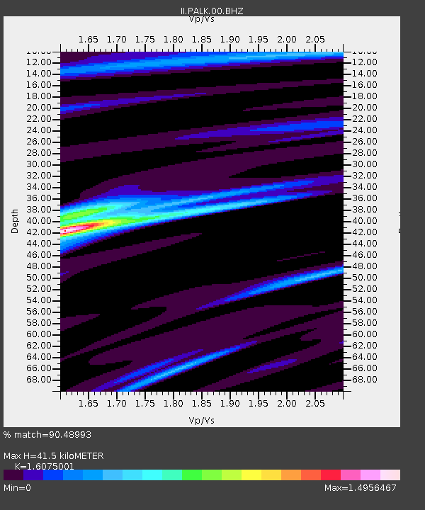
PALK Pallekele, Sri Lanka - Earthquake Result Viewer
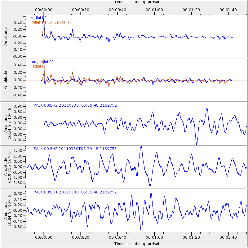
Earthquake location: Off East Coast Of Honshu, Japan
Earthquake latitude/longitude: 36.1/142.5
Earthquake time(UTC): 2011/03/30 (089) 05:29:52 GMT
Earthquake Depth: 11 km
Earthquake Magnitude: 5.7 MW, 5.6 MB, 5.8 MW, 5.8 MS
Earthquake Catalog/Contributor: NEIC PDE/NEIC PDE-M
Network: II Global Seismograph Network (GSN - IRIS/IDA)
Station: PALK Pallekele, Sri Lanka
Lat/Lon: 7.27 N/80.70 E
Elevation: 460 m
Distance: 63.0 deg
Az: 258.751 deg
Baz: 53.152 deg
Ray Param: 0.059849665
Estimated Moho Depth: 41.5 km
Estimated Crust Vp/Vs: 1.61
Assumed Crust Vp: 6.545 km/s
Estimated Crust Vs: 4.072 km/s
Estimated Crust Poisson's Ratio: 0.18
Radial Match: 90.48993 %
Radial Bump: 400
Transverse Match: 74.913574 %
Transverse Bump: 400
SOD ConfigId: 558545
Insert Time: 2013-09-18 15:12:03.930 +0000
GWidth: 2.5
Max Bumps: 400
Tol: 0.001

Signal To Noise

ChannelStoNSTALTA
II:PALK:00:BHZ:20110330T05:39:48.218975Z3.38455944.595727E-71.3578509E-7
II:PALK:00:BH1:20110330T05:39:48.218975Z1.04246821.0365751E-79.94347E-8
II:PALK:00:BH2:20110330T05:39:48.218975Z2.28168922.0220408E-78.862034E-8
Arrivals
Ps4.1 SECOND
PpPs16 SECOND
PsPs/PpSs20 SECOND