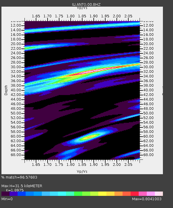
ANTO Ankara, Turkey - Earthquake Result Viewer
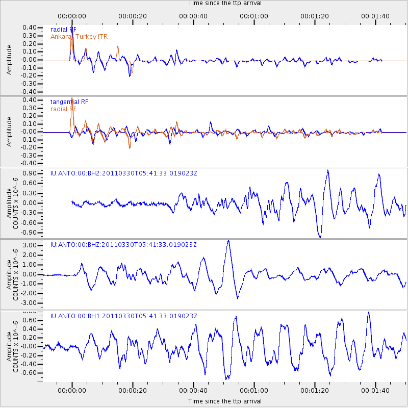
Earthquake location: Off East Coast Of Honshu, Japan
Earthquake latitude/longitude: 36.1/142.5
Earthquake time(UTC): 2011/03/30 (089) 05:29:52 GMT
Earthquake Depth: 11 km
Earthquake Magnitude: 5.7 MW, 5.6 MB, 5.8 MW, 5.8 MS
Earthquake Catalog/Contributor: NEIC PDE/NEIC PDE-M
Network: IU Global Seismograph Network (GSN - IRIS/USGS)
Station: ANTO Ankara, Turkey
Lat/Lon: 39.87 N/32.79 E
Elevation: 1090 m
Distance: 80.5 deg
Az: 312.708 deg
Baz: 50.607 deg
Ray Param: 0.048239477
Estimated Moho Depth: 31.5 km
Estimated Crust Vp/Vs: 1.90
Assumed Crust Vp: 6.159 km/s
Estimated Crust Vs: 3.246 km/s
Estimated Crust Poisson's Ratio: 0.31
Radial Match: 96.57683 %
Radial Bump: 395
Transverse Match: 83.75124 %
Transverse Bump: 400
SOD ConfigId: 558545
Insert Time: 2013-09-18 15:12:25.286 +0000
GWidth: 2.5
Max Bumps: 400
Tol: 0.001

Signal To Noise

ChannelStoNSTALTA
IU:ANTO:00:BHZ:20110330T05:41:33.019023Z7.6548954.6344488E-76.054229E-8
IU:ANTO:00:BH1:20110330T05:41:33.019023Z2.9485461.0251096E-73.4766614E-8
IU:ANTO:00:BH2:20110330T05:41:33.019023Z2.2346171.12124496E-75.017616E-8
Arrivals
Ps4.7 SECOND
PpPs14 SECOND
PsPs/PpSs19 SECOND