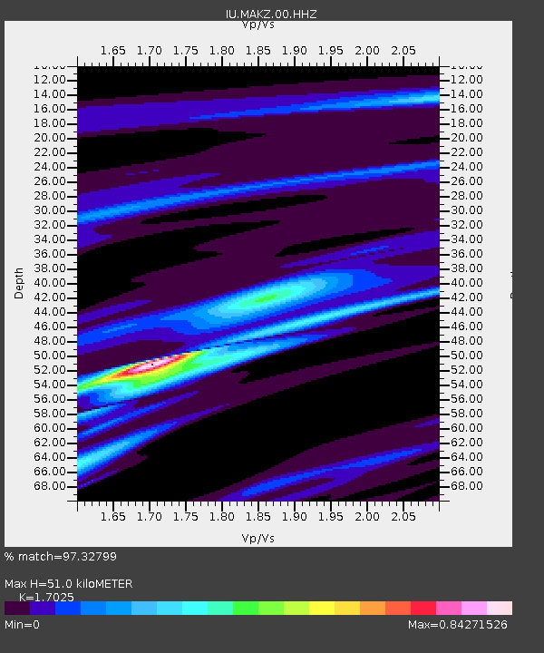
MAKZ Makanchi, Kazakhstan - Earthquake Result Viewer
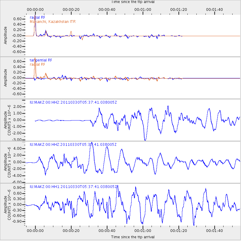
Earthquake location: Off East Coast Of Honshu, Japan
Earthquake latitude/longitude: 36.1/142.5
Earthquake time(UTC): 2011/03/30 (089) 05:29:52 GMT
Earthquake Depth: 11 km
Earthquake Magnitude: 5.7 MW, 5.6 MB, 5.8 MW, 5.8 MS
Earthquake Catalog/Contributor: NEIC PDE/NEIC PDE-M
Network: IU Global Seismograph Network (GSN - IRIS/USGS)
Station: MAKZ Makanchi, Kazakhstan
Lat/Lon: 46.81 N/81.98 E
Elevation: 600 m
Distance: 45.5 deg
Az: 303.093 deg
Baz: 80.842 deg
Ray Param: 0.071221285
Estimated Moho Depth: 51.0 km
Estimated Crust Vp/Vs: 1.70
Assumed Crust Vp: 6.571 km/s
Estimated Crust Vs: 3.859 km/s
Estimated Crust Poisson's Ratio: 0.24
Radial Match: 97.32799 %
Radial Bump: 255
Transverse Match: 89.4363 %
Transverse Bump: 400
SOD ConfigId: 558545
Insert Time: 2013-09-18 15:13:17.355 +0000
GWidth: 2.5
Max Bumps: 400
Tol: 0.001

Signal To Noise

ChannelStoNSTALTA
IU:MAKZ:00:HHZ:20110330T05:37:41.038005Z9.8703647.4884997E-77.586853E-8
IU:MAKZ:00:HH1:20110330T05:37:41.038005Z3.21192749.659747E-83.007461E-8
IU:MAKZ:00:HH2:20110330T05:37:41.038005Z8.6975583.7260955E-74.2840707E-8
Arrivals
Ps5.8 SECOND
PpPs20 SECOND
PsPs/PpSs25 SECOND