You are here: Home > Network List > IU - Global Seismograph Network (GSN - IRIS/USGS) Stations List
> Station POHA Pohakuloa, Hawaii, USA > Earthquake Result Viewer
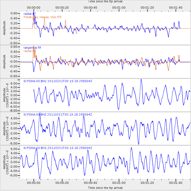
POHA Pohakuloa, Hawaii, USA - Earthquake Result Viewer
*The percent match for this event was below the threshold and hence no stack was calculated.
| Earthquake location: |
Fiji Islands Region |
| Earthquake latitude/longitude: |
-16.5/-177.5 |
| Earthquake time(UTC): |
2011/03/31 (090) 00:11:58 GMT |
| Earthquake Depth: |
16 km |
| Earthquake Magnitude: |
6.4 MW, 5.7 MB, 6.3 MS, 6.3 MW |
| Earthquake Catalog/Contributor: |
NEIC PDE/NEIC PDE-M |
|
| Network: |
IU Global Seismograph Network (GSN - IRIS/USGS) |
| Station: |
POHA Pohakuloa, Hawaii, USA |
| Lat/Lon: |
19.76 N/155.53 W |
| Elevation: |
1990 m |
|
| Distance: |
42.0 deg |
| Az: |
31.766 deg |
| Baz: |
212.419 deg |
| Ray Param: |
$rayparam |
*The percent match for this event was below the threshold and hence was not used in the summary stack. |
|
| Radial Match: |
56.482616 % |
| Radial Bump: |
400 |
| Transverse Match: |
37.844105 % |
| Transverse Bump: |
400 |
| SOD ConfigId: |
558545 |
| Insert Time: |
2013-09-18 15:15:38.474 +0000 |
| GWidth: |
2.5 |
| Max Bumps: |
400 |
| Tol: |
0.001 |
|
Signal To Noise
| Channel | StoN | STA | LTA |
| IU:POHA:00:BHZ:20110331T00:19:18.268994Z | 2.5190563 | 3.793278E-6 | 1.5058329E-6 |
| IU:POHA:00:BH1:20110331T00:19:18.268994Z | 2.3931901 | 4.281359E-6 | 1.7889759E-6 |
| IU:POHA:00:BH2:20110331T00:19:18.268994Z | 0.6867508 | 1.6778313E-6 | 2.443144E-6 |
| Arrivals |
| Ps | |
| PpPs | |
| PsPs/PpSs | |


