You are here: Home > Network List > KZ - Kazakhstan Network Stations List
> Station KUR21 Cross-array, Kurchatov, Kazakstan > Earthquake Result Viewer
KUR21 Cross-array, Kurchatov, Kazakstan - Earthquake Result Viewer
| Earthquake location: |
Near East Coast Of Honshu, Japan |
| Earthquake latitude/longitude: |
38.9/141.8 |
| Earthquake time(UTC): |
2011/03/31 (090) 07:15:30 GMT |
| Earthquake Depth: |
42 km |
| Earthquake Magnitude: |
6.0 MW, 5.6 MS, 5.7 MB, 6.1 MW |
| Earthquake Catalog/Contributor: |
NEIC PDE/NEIC PDE-M |
|
| Network: |
KZ Kazakhstan Network |
| Station: |
KUR21 Cross-array, Kurchatov, Kazakstan |
| Lat/Lon: |
50.62 N/78.53 E |
| Elevation: |
200 m |
|
| Distance: |
45.1 deg |
| Az: |
306.575 deg |
| Baz: |
79.57 deg |
| Ray Param: |
0.07138729 |
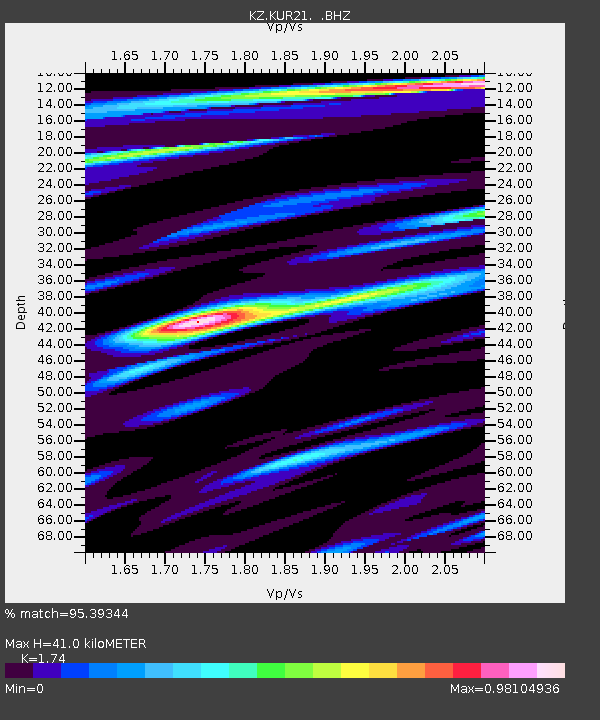
| Estimated Moho Depth: |
41.0 km |
| Estimated Crust Vp/Vs: |
1.74 |
| Assumed Crust Vp: |
6.552 km/s |
| Estimated Crust Vs: |
3.766 km/s |
| Estimated Crust Poisson's Ratio: |
0.25 |
|
| Radial Match: |
95.39344 % |
| Radial Bump: |
400 |
| Transverse Match: |
95.739334 % |
| Transverse Bump: |
400 |
| SOD ConfigId: |
558545 |
| Insert Time: |
2013-09-18 15:18:26.445 +0000 |
| GWidth: |
2.5 |
| Max Bumps: |
400 |
| Tol: |
0.001 |
|

Signal To Noise
| Channel | StoN | STA | LTA |
| KZ:KUR21: :BHZ:20110331T07:23:11.899991Z | 61.651398 | 4.385744E-6 | 7.1137784E-8 |
| KZ:KUR21: :BH1:20110331T07:23:11.899991Z | 52.304947 | 2.4073427E-6 | 4.6025143E-8 |
| KZ:KUR21: :BH2:20110331T07:23:11.899991Z | 11.367065 | 6.505841E-7 | 5.7234136E-8 |
| Arrivals |
| Ps | 5.0 SECOND |
| PpPs | 16 SECOND |
| PsPs/PpSs | 21 SECOND |


