You are here: Home > Network List > IU - Global Seismograph Network (GSN - IRIS/USGS) Stations List
> Station POHA Pohakuloa, Hawaii, USA > Earthquake Result Viewer
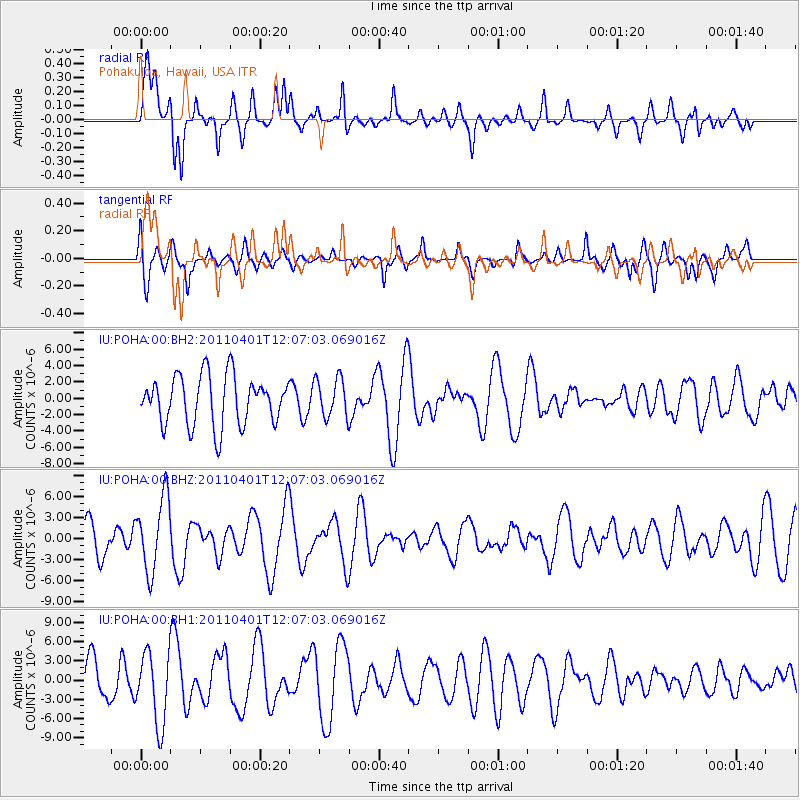
POHA Pohakuloa, Hawaii, USA - Earthquake Result Viewer
*The percent match for this event was below the threshold and hence no stack was calculated.
| Earthquake location: |
Eastern Honshu, Japan |
| Earthquake latitude/longitude: |
39.3/141.9 |
| Earthquake time(UTC): |
2011/04/01 (091) 11:57:54 GMT |
| Earthquake Depth: |
41 km |
| Earthquake Magnitude: |
5.9 MW, 5.8 MB, 6.0 MW |
| Earthquake Catalog/Contributor: |
NEIC PDE/NEIC PDE-M |
|
| Network: |
IU Global Seismograph Network (GSN - IRIS/USGS) |
| Station: |
POHA Pohakuloa, Hawaii, USA |
| Lat/Lon: |
19.76 N/155.53 W |
| Elevation: |
1990 m |
|
| Distance: |
56.7 deg |
| Az: |
90.938 deg |
| Baz: |
304.569 deg |
| Ray Param: |
$rayparam |
*The percent match for this event was below the threshold and hence was not used in the summary stack. |
|
| Radial Match: |
61.071537 % |
| Radial Bump: |
379 |
| Transverse Match: |
62.95903 % |
| Transverse Bump: |
400 |
| SOD ConfigId: |
558545 |
| Insert Time: |
2013-09-18 15:20:23.187 +0000 |
| GWidth: |
2.5 |
| Max Bumps: |
400 |
| Tol: |
0.001 |
|
Signal To Noise
| Channel | StoN | STA | LTA |
| IU:POHA:00:BHZ:20110401T12:07:03.069016Z | 1.7604642 | 5.2918094E-6 | 3.0059173E-6 |
| IU:POHA:00:BH1:20110401T12:07:03.069016Z | 2.1144295 | 5.6261124E-6 | 2.6608182E-6 |
| IU:POHA:00:BH2:20110401T12:07:03.069016Z | 0.80065626 | 2.3980617E-6 | 2.9951202E-6 |
| Arrivals |
| Ps | |
| PpPs | |
| PsPs/PpSs | |


