You are here: Home > Network List > CN - Canadian National Seismograph Network Stations List
> Station FRB IQALUIT, N.W.T. > Earthquake Result Viewer
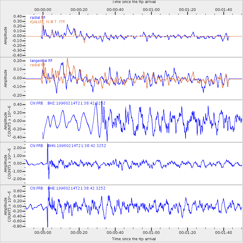
FRB IQALUIT, N.W.T. - Earthquake Result Viewer
*The percent match for this event was below the threshold and hence no stack was calculated.
| Earthquake location: |
Southeast Of Honshu, Japan |
| Earthquake latitude/longitude: |
29.2/140.4 |
| Earthquake time(UTC): |
1996/02/14 (045) 21:26:56 GMT |
| Earthquake Depth: |
142 km |
| Earthquake Magnitude: |
5.9 MB |
| Earthquake Catalog/Contributor: |
WHDF/NEIC |
|
| Network: |
CN Canadian National Seismograph Network |
| Station: |
FRB IQALUIT, N.W.T. |
| Lat/Lon: |
63.75 N/68.55 W |
| Elevation: |
18 m |
|
| Distance: |
84.6 deg |
| Az: |
12.48 deg |
| Baz: |
334.864 deg |
| Ray Param: |
$rayparam |
*The percent match for this event was below the threshold and hence was not used in the summary stack. |
|
| Radial Match: |
50.569256 % |
| Radial Bump: |
400 |
| Transverse Match: |
60.598793 % |
| Transverse Bump: |
400 |
| SOD ConfigId: |
4480 |
| Insert Time: |
2010-02-27 05:56:25.979 +0000 |
| GWidth: |
2.5 |
| Max Bumps: |
400 |
| Tol: |
0.001 |
|
Signal To Noise
| Channel | StoN | STA | LTA |
| CN:FRB: :BHN:19960214T21:38:42.325Z | 3.023737 | 6.8303603E-7 | 2.2589134E-7 |
| CN:FRB: :BHE:19960214T21:38:42.325Z | 1.985726 | 2.4999076E-7 | 1.2589388E-7 |
| CN:FRB: :BHZ:19960214T21:38:42.325Z | 1.9581028 | 2.7743584E-7 | 1.4168604E-7 |
| Arrivals |
| Ps | |
| PpPs | |
| PsPs/PpSs | |


