You are here: Home > Network List > II - Global Seismograph Network (GSN - IRIS/IDA) Stations List
> Station KURK Kurchatov, Kazakhstan > Earthquake Result Viewer
KURK Kurchatov, Kazakhstan - Earthquake Result Viewer
| Earthquake location: |
South Of Java, Indonesia |
| Earthquake latitude/longitude: |
-9.8/107.7 |
| Earthquake time(UTC): |
2011/04/03 (093) 20:06:40 GMT |
| Earthquake Depth: |
14 km |
| Earthquake Magnitude: |
6.7 MW, 6.3 MS, 6.4 MB, 6.7 MW |
| Earthquake Catalog/Contributor: |
NEIC PDE/NEIC PDE-M |
|
| Network: |
II Global Seismograph Network (GSN - IRIS/IDA) |
| Station: |
KURK Kurchatov, Kazakhstan |
| Lat/Lon: |
50.72 N/78.62 E |
| Elevation: |
184 m |
|
| Distance: |
65.4 deg |
| Az: |
340.138 deg |
| Baz: |
148.219 deg |
| Ray Param: |
0.058292124 |
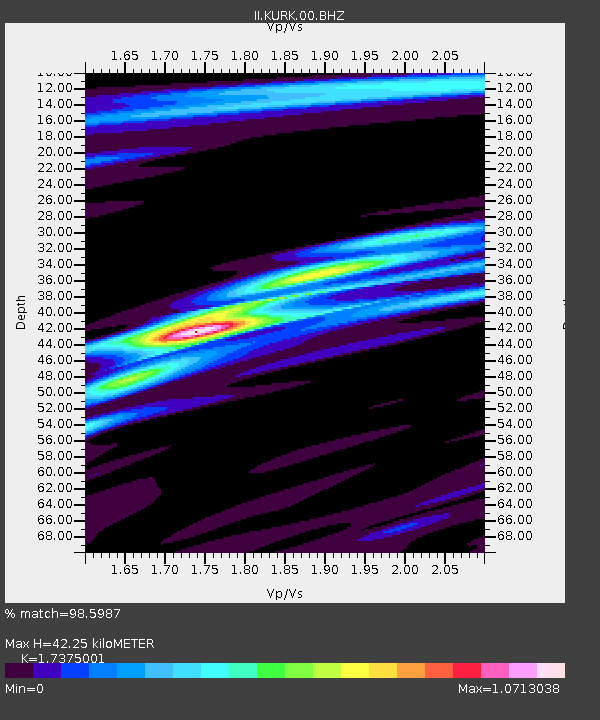
| Estimated Moho Depth: |
42.25 km |
| Estimated Crust Vp/Vs: |
1.74 |
| Assumed Crust Vp: |
6.552 km/s |
| Estimated Crust Vs: |
3.771 km/s |
| Estimated Crust Poisson's Ratio: |
0.25 |
|
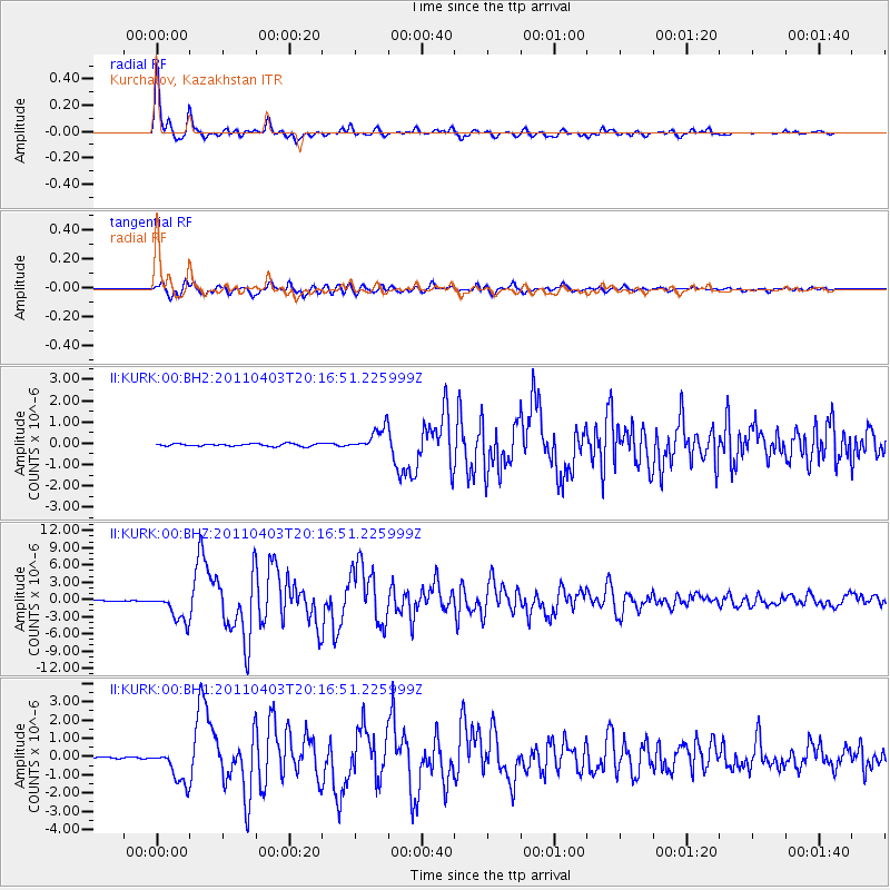
| Radial Match: |
98.5987 % |
| Radial Bump: |
302 |
| Transverse Match: |
93.78451 % |
| Transverse Bump: |
400 |
| SOD ConfigId: |
558545 |
| Insert Time: |
2013-09-18 15:30:59.426 +0000 |
| GWidth: |
2.5 |
| Max Bumps: |
400 |
| Tol: |
0.001 |
|
Signal To Noise
| Channel | StoN | STA | LTA |
| II:KURK:00:BHZ:20110403T20:16:51.225999Z | 47.670563 | 2.5178015E-6 | 5.281669E-8 |
| II:KURK:00:BH1:20110403T20:16:51.225999Z | 22.244759 | 9.747298E-7 | 4.3818403E-8 |
| II:KURK:00:BH2:20110403T20:16:51.225999Z | 9.008735 | 5.392153E-7 | 5.985473E-8 |
| Arrivals |
| Ps | 5.0 SECOND |
| PpPs | 17 SECOND |
| PsPs/PpSs | 22 SECOND |


