You are here: Home > Network List > IU - Global Seismograph Network (GSN - IRIS/USGS) Stations List
> Station ANTO Ankara, Turkey > Earthquake Result Viewer
ANTO Ankara, Turkey - Earthquake Result Viewer

| Earthquake location: |
South Of Java, Indonesia |
| Earthquake latitude/longitude: |
-9.8/107.7 |
| Earthquake time(UTC): |
2011/04/03 (093) 20:06:40 GMT |
| Earthquake Depth: |
14 km |
| Earthquake Magnitude: |
6.7 MW, 6.3 MS, 6.4 MB, 6.7 MW |
| Earthquake Catalog/Contributor: |
NEIC PDE/NEIC PDE-M |
|
| Network: |
IU Global Seismograph Network (GSN - IRIS/USGS) |
| Station: |
ANTO Ankara, Turkey |
| Lat/Lon: |
39.87 N/32.79 E |
| Elevation: |
1090 m |
|
| Distance: |
84.9 deg |
| Az: |
311.753 deg |
| Baz: |
107.21 deg |
| Ray Param: |
0.04515207 |
| Estimated Moho Depth: |
34.75 km |
| Estimated Crust Vp/Vs: |
1.60 |
| Assumed Crust Vp: |
6.159 km/s |
| Estimated Crust Vs: |
3.849 km/s |
| Estimated Crust Poisson's Ratio: |
0.18 |
|
| Radial Match: |
92.07085 % |
| Radial Bump: |
400 |
| Transverse Match: |
82.39991 % |
| Transverse Bump: |
400 |
| SOD ConfigId: |
558545 |
| Insert Time: |
2013-09-18 15:31:27.886 +0000 |
| GWidth: |
2.5 |
| Max Bumps: |
400 |
| Tol: |
0.001 |
|
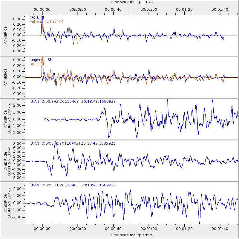
Signal To Noise
| Channel | StoN | STA | LTA |
| IU:ANTO:00:BHZ:20110403T20:18:43.168992Z | 29.925333 | 1.7982761E-6 | 6.00921E-8 |
| IU:ANTO:00:BH1:20110403T20:18:43.168992Z | 3.7647426 | 2.1388031E-7 | 5.6811405E-8 |
| IU:ANTO:00:BH2:20110403T20:18:43.168992Z | 8.010594 | 5.760998E-7 | 7.191724E-8 |
| Arrivals |
| Ps | 3.5 SECOND |
| PpPs | 14 SECOND |
| PsPs/PpSs | 18 SECOND |


