You are here: Home > Network List > IU - Global Seismograph Network (GSN - IRIS/USGS) Stations List
> Station HNR Honiara, Solomon Islands > Earthquake Result Viewer
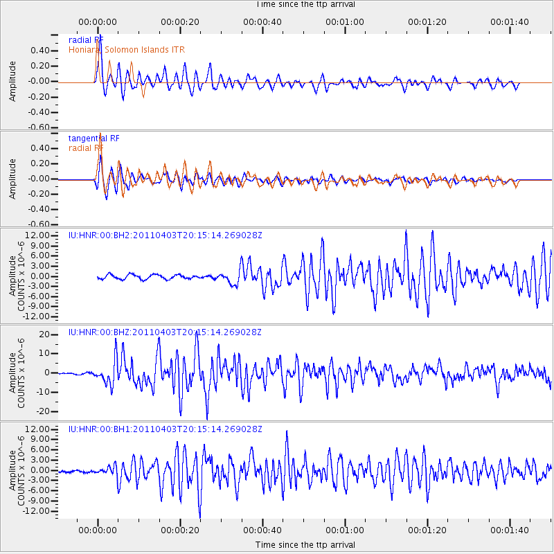
HNR Honiara, Solomon Islands - Earthquake Result Viewer
*The percent match for this event was below the threshold and hence no stack was calculated.
| Earthquake location: |
South Of Java, Indonesia |
| Earthquake latitude/longitude: |
-9.8/107.7 |
| Earthquake time(UTC): |
2011/04/03 (093) 20:06:40 GMT |
| Earthquake Depth: |
14 km |
| Earthquake Magnitude: |
6.7 MW, 6.3 MS, 6.4 MB, 6.7 MW |
| Earthquake Catalog/Contributor: |
NEIC PDE/NEIC PDE-M |
|
| Network: |
IU Global Seismograph Network (GSN - IRIS/USGS) |
| Station: |
HNR Honiara, Solomon Islands |
| Lat/Lon: |
9.44 S/159.95 E |
| Elevation: |
100 m |
|
| Distance: |
51.5 deg |
| Az: |
94.246 deg |
| Baz: |
264.913 deg |
| Ray Param: |
$rayparam |
*The percent match for this event was below the threshold and hence was not used in the summary stack. |
|
| Radial Match: |
94.85614 % |
| Radial Bump: |
400 |
| Transverse Match: |
93.76283 % |
| Transverse Bump: |
400 |
| SOD ConfigId: |
558545 |
| Insert Time: |
2013-09-18 15:31:39.356 +0000 |
| GWidth: |
2.5 |
| Max Bumps: |
400 |
| Tol: |
0.001 |
|
Signal To Noise
| Channel | StoN | STA | LTA |
| IU:HNR:00:BHZ:20110403T20:15:14.269028Z | 17.17834 | 6.411126E-6 | 3.7320984E-7 |
| IU:HNR:00:BH1:20110403T20:15:14.269028Z | 4.7376566 | 1.3598645E-6 | 2.8703317E-7 |
| IU:HNR:00:BH2:20110403T20:15:14.269028Z | 3.2214177 | 2.0651598E-6 | 6.410718E-7 |
| Arrivals |
| Ps | |
| PpPs | |
| PsPs/PpSs | |


