You are here: Home > Network List > IU - Global Seismograph Network (GSN - IRIS/USGS) Stations List
> Station KMBO Kilima Mbogo, Kenya > Earthquake Result Viewer
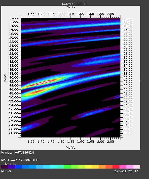
KMBO Kilima Mbogo, Kenya - Earthquake Result Viewer
| Earthquake location: |
South Of Java, Indonesia |
| Earthquake latitude/longitude: |
-9.8/107.7 |
| Earthquake time(UTC): |
2011/04/03 (093) 20:06:40 GMT |
| Earthquake Depth: |
14 km |
| Earthquake Magnitude: |
6.7 MW, 6.3 MS, 6.4 MB, 6.7 MW |
| Earthquake Catalog/Contributor: |
NEIC PDE/NEIC PDE-M |
|
| Network: |
IU Global Seismograph Network (GSN - IRIS/USGS) |
| Station: |
KMBO Kilima Mbogo, Kenya |
| Lat/Lon: |
1.13 S/37.25 E |
| Elevation: |
1950 m |
|
| Distance: |
70.5 deg |
| Az: |
272.287 deg |
| Baz: |
99.983 deg |
| Ray Param: |
0.054908335 |
| Estimated Moho Depth: |
42.25 km |
| Estimated Crust Vp/Vs: |
1.71 |
| Assumed Crust Vp: |
6.601 km/s |
| Estimated Crust Vs: |
3.86 km/s |
| Estimated Crust Poisson's Ratio: |
0.24 |
|
| Radial Match: |
97.449814 % |
| Radial Bump: |
256 |
| Transverse Match: |
88.240364 % |
| Transverse Bump: |
400 |
| SOD ConfigId: |
558545 |
| Insert Time: |
2013-09-18 15:31:46.057 +0000 |
| GWidth: |
2.5 |
| Max Bumps: |
400 |
| Tol: |
0.001 |
|

Signal To Noise
| Channel | StoN | STA | LTA |
| IU:KMBO:00:BHZ:20110403T20:17:23.468979Z | 16.17576 | 7.978092E-7 | 4.9321276E-8 |
| IU:KMBO:00:BH1:20110403T20:17:23.468979Z | 1.609659 | 6.3390225E-8 | 3.9381153E-8 |
| IU:KMBO:00:BH2:20110403T20:17:23.468979Z | 7.9757586 | 3.759036E-7 | 4.7130765E-8 |
| Arrivals |
| Ps | 4.7 SECOND |
| PpPs | 17 SECOND |
| PsPs/PpSs | 21 SECOND |


