You are here: Home > Network List > CN - Canadian National Seismograph Network Stations List
> Station FRB IQALUIT, N.W.T. > Earthquake Result Viewer
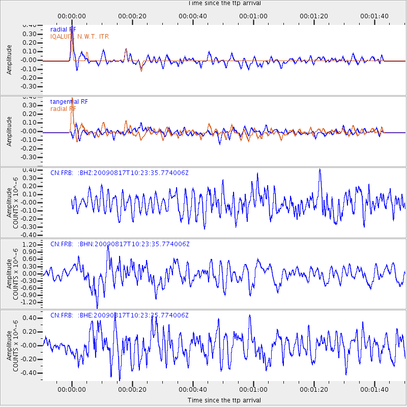
FRB IQALUIT, N.W.T. - Earthquake Result Viewer
*The percent match for this event was below the threshold and hence no stack was calculated.
| Earthquake location: |
Southwestern Ryukyu Isl., Japan |
| Earthquake latitude/longitude: |
23.4/123.5 |
| Earthquake time(UTC): |
2009/08/17 (229) 10:10:55 GMT |
| Earthquake Depth: |
10 km |
| Earthquake Magnitude: |
5.9 MB, 6.2 MS, 6.1 MW, 6.1 MW |
| Earthquake Catalog/Contributor: |
WHDF/NEIC |
|
| Network: |
CN Canadian National Seismograph Network |
| Station: |
FRB IQALUIT, N.W.T. |
| Lat/Lon: |
63.75 N/68.55 W |
| Elevation: |
18 m |
|
| Distance: |
92.6 deg |
| Az: |
5.344 deg |
| Baz: |
348.91 deg |
| Ray Param: |
$rayparam |
*The percent match for this event was below the threshold and hence was not used in the summary stack. |
|
| Radial Match: |
70.72717 % |
| Radial Bump: |
400 |
| Transverse Match: |
62.867104 % |
| Transverse Bump: |
400 |
| SOD ConfigId: |
2622 |
| Insert Time: |
2010-02-27 05:56:41.152 +0000 |
| GWidth: |
2.5 |
| Max Bumps: |
400 |
| Tol: |
0.001 |
|
Signal To Noise
| Channel | StoN | STA | LTA |
| CN:FRB: :BHN:20090817T10:23:35.774006Z | 2.405121 | 3.290686E-7 | 1.3681996E-7 |
| CN:FRB: :BHE:20090817T10:23:35.774006Z | 1.2776151 | 1.3369097E-7 | 1.0464103E-7 |
| CN:FRB: :BHZ:20090817T10:23:35.774006Z | 0.9534658 | 9.489242E-8 | 9.9523675E-8 |
| Arrivals |
| Ps | |
| PpPs | |
| PsPs/PpSs | |


