You are here: Home > Network List > 3C - Arizona Rapid Array Array Mobilization Program Stations List
> Station DUN1 Lazy B, AZ, USA > Earthquake Result Viewer
DUN1 Lazy B, AZ, USA - Earthquake Result Viewer
| Earthquake location: |
Tonga Islands |
| Earthquake latitude/longitude: |
-15.0/-173.5 |
| Earthquake time(UTC): |
2014/09/03 (246) 07:43:31 GMT |
| Earthquake Depth: |
10 km |
| Earthquake Magnitude: |
5.7 MB |
| Earthquake Catalog/Contributor: |
NEIC PDE/NEIC COMCAT |
|
| Network: |
3C Arizona Rapid Array Array Mobilization Program |
| Station: |
DUN1 Lazy B, AZ, USA |
| Lat/Lon: |
32.55 N/109.09 W |
| Elevation: |
1257 m |
|
| Distance: |
77.6 deg |
| Az: |
51.254 deg |
| Baz: |
243.178 deg |
| Ray Param: |
0.05020366 |
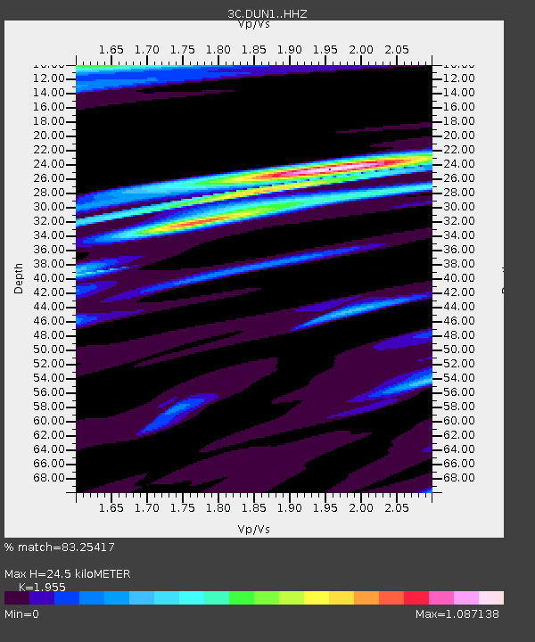
| Estimated Moho Depth: |
24.5 km |
| Estimated Crust Vp/Vs: |
1.96 |
| Assumed Crust Vp: |
6.276 km/s |
| Estimated Crust Vs: |
3.21 km/s |
| Estimated Crust Poisson's Ratio: |
0.32 |
|
| Radial Match: |
83.25417 % |
| Radial Bump: |
400 |
| Transverse Match: |
65.29354 % |
| Transverse Bump: |
400 |
| SOD ConfigId: |
3390531 |
| Insert Time: |
2019-04-13 19:21:35.417 +0000 |
| GWidth: |
2.5 |
| Max Bumps: |
400 |
| Tol: |
0.001 |
|

Signal To Noise
| Channel | StoN | STA | LTA |
| 3C:DUN1: :HHZ:20140903T07:54:56.129993Z | 5.8537335 | 5.0933403E-7 | 8.701012E-8 |
| 3C:DUN1: :HHN:20140903T07:54:56.129993Z | 0.94005156 | 7.685157E-8 | 8.17525E-8 |
| 3C:DUN1: :HHE:20140903T07:54:56.129993Z | 2.8309937 | 1.8733814E-7 | 6.617399E-8 |
| Arrivals |
| Ps | 3.8 SECOND |
| PpPs | 11 SECOND |
| PsPs/PpSs | 15 SECOND |


