You are here: Home > Network List > IU - Global Seismograph Network (GSN - IRIS/USGS) Stations List
> Station HNR Honiara, Solomon Islands > Earthquake Result Viewer
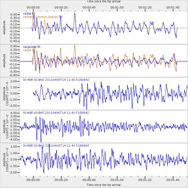
HNR Honiara, Solomon Islands - Earthquake Result Viewer
*The percent match for this event was below the threshold and hence no stack was calculated.
| Earthquake location: |
Northern Sumatra, Indonesia |
| Earthquake latitude/longitude: |
1.6/97.1 |
| Earthquake time(UTC): |
2011/04/06 (096) 14:01:42 GMT |
| Earthquake Depth: |
20 km |
| Earthquake Magnitude: |
6.0 MW, 5.8 MW, 5.9 MB, 6.0 MS |
| Earthquake Catalog/Contributor: |
NEIC PDE/NEIC PDE-M |
|
| Network: |
IU Global Seismograph Network (GSN - IRIS/USGS) |
| Station: |
HNR Honiara, Solomon Islands |
| Lat/Lon: |
9.44 S/159.95 E |
| Elevation: |
100 m |
|
| Distance: |
63.6 deg |
| Az: |
101.299 deg |
| Baz: |
276.532 deg |
| Ray Param: |
$rayparam |
*The percent match for this event was below the threshold and hence was not used in the summary stack. |
|
| Radial Match: |
74.294495 % |
| Radial Bump: |
400 |
| Transverse Match: |
75.4381 % |
| Transverse Bump: |
400 |
| SOD ConfigId: |
558545 |
| Insert Time: |
2013-09-18 15:39:24.936 +0000 |
| GWidth: |
2.5 |
| Max Bumps: |
400 |
| Tol: |
0.001 |
|
Signal To Noise
| Channel | StoN | STA | LTA |
| IU:HNR:00:BHZ:20110406T14:11:40.518984Z | 3.0119424 | 1.4081152E-6 | 4.6751066E-7 |
| IU:HNR:00:BH1:20110406T14:11:40.518984Z | 1.1332618 | 5.1636334E-7 | 4.5564346E-7 |
| IU:HNR:00:BH2:20110406T14:11:40.518984Z | 1.1588511 | 6.07501E-7 | 5.2422695E-7 |
| Arrivals |
| Ps | |
| PpPs | |
| PsPs/PpSs | |


